Local government office nearby FXB INDIA SURAKSHA
Coronavirus disease (COVID-19) Situation
confirmed cases
45035393
deaths
533570
India
Local government office nearby FXB INDIA SURAKSHA
FXB INDIA SURAKSHA
Zoo By Lane 9, Zoo Tiniali, Guwahati India
contacts phone
:
+91
Latitude:
26.1727965
, Longitude:
91.7749769
read more
nearest Local government office
76 m
Ganga placers
Zoo Road Tiniali,sugam path ,House no 1 ,2nd floor,Guwahati 781024, Guwahati
Local government office
read more
117 m
Pratham Education Foundation Assam
Zoo Tiniali, Guwahati
Local government office
read more
121 m
Pratham Education Foundation State Office Assam
Bylane Number 9, Zoo Tiniali, Guwahati
Local government office
read more
125 m
FXB INDIA SURAKSHA
Road No.9, Zoo Road, Zoo Tiniali, Guwahati
Local government office
read more
428 m
Guwahati Jal Board, Zoo Road Water Supply
14, Bhayamama Path, Ambikagirinagar, Guwahati
Local government office
read more
489 m
Roshni Consultancy & To Let Service
RGB Road AIDC Zoo Tiniali Sagorika Path House No-5, Guwahati
Local government office
read more
553 m
Ceo, Single Window Agency
C/O Assam Industrial Development Corporation Limited, R G, RG Baruah Road, Guwahati
Local government office
read more
726 m
Assam State Primary Teacher's Association
Sikshak Bhawan, R.G. Bargah Road, Commerce Point, Chandmari, Guwahati
Local government office
read more
842 m
Tech Booster Institute of Professional Studies
Opposite of Shani Mandir, Jonali,, Zoo Road, Guwahati
Local government office
read more
954 m
O/O Directorate Of Census Operations,Assam
Bhangagarh Flyover, Bhangagarh, Guwahati
Local government office
read more
1.034 km
NRC Assam, Office Of The State Coordinator
1st Floor, Achyut Plaza, Guwahati-Shillong Road, Bhangagarh, Guwahati
Local government office
read more
1.08 km
A D Advertising & Consultancy
Asian Complex,(Hotel Asian palace Compound) GS Road,Bhangagarh Bora Service, Near S B Deora College, Guwahati
Local government office
read more
1.168 km
Pollution Control Board, Assam,
Railway Colony Road, Railway Colony, Bamunimaidam, Guwahati
Local government office
read more
1.281 km
Public Health Engineering Department
2, Milanpur Road, West Jyotinagar, Bamunimaidam, Guwahati
Local government office
read more
1.301 km
Assam Science Technology And Environment Council
Bigyan Bhavan, GS Road, Near IDBI Bank, Bhangagarh, Guwahati
Local government office
read more
1.359 km
Skyline Communication
South Sarania Road, Manipuri Rajbari, Guwahati
Local government office
read more
1.443 km
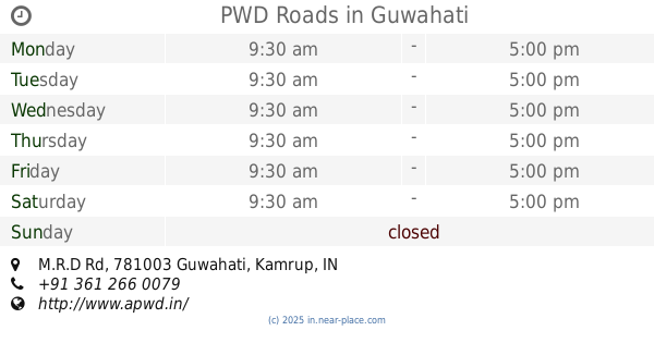
PWD Roads
M.R.D Rd, Krishna Nagar, Chandmari, Guwahati
Local government office
read more
1.646 km
Office of the Public Works Department
Bhangagarh, Guwahati
Local government office
read more
1.688 km
PWD MCC Sub Division
26, GMC Hostel Road, Ananda Nagar, Christian Basti, Guwahati
Local government office
read more
1.728 km
Industry HQ Assam
House no 14, Maniram Dewan Road, Railway Colony, Chandmari, Guwahati
Local government office
read more
1.816 km
Assam Small Industries Development Corporation Limited
Maniram Dewan Road, Bamunimaidam, Guwahati
Local government office
read more
1.831 km
Matrimony, Marriage Service in Guwahati by Shaadi.com
1st floor, Royal Arcade Building Part 1,, Ulubari, Guwahati
Local government office
read more
1.879 km
Welkin Visa n Travel
Adam's Plaza, Arunodoi Path, GS Road, Christian Basti, Guwahati
Local government office
read more
2.022 km
Office Of The Manager Ulubari ELCT
Freedom Fighter Rd, ASEB Rd, Ulubari, Guwahati
Local government office
read more
2.092 km
Food And Nutrition Board Assam
Chenikuthi, Guwahati
Local government office
read more
📑
all categories
Accounting
Administrative area level 1
Administrative area level 2
Airport
Amusement park
Aquarium
Art gallery
Atm
Bakery
Bank
Bar
Beauty salon
Bicycle store
Book store
Bowling alley
Bus station
Cafe
Campground
Car dealer
Car rental
Car repair
Car wash
Casino
Cemetery
Church
City hall
Clothing store
Colloquial area
Convenience store
Courthouse
Dentist
Department store
Doctor
Electrician
Electronics store
Embassy
Finance
Fire station
Florist
Food
Funeral home
Furniture store
Gas station
General contractor
Grocery or supermarket
Gym
Hair care
Hardware store
Health
Hindu Temple
Home goods store
Hospital
Insurance agency
Intersection
Jewelry store
Laundry
Lawyer
Library
Light rail station
Liquor store
Local government office
Locality
Locksmith
Lodging
Meal delivery
Meal takeaway
Mosque
Movie rental
Movie theater
Moving company
Museum
Natural feature
Neighborhood
Night club
Painter
Park
Parking
Pet store
Pharmacy
Physiotherapist
Place of worship
Plumber
Point of interest
Police
Political
Post office
Premise
Real estate agency
Restaurant
Roofing contractor
Route
Rv park, camping
School
Shoe store
Shopping mall
Spa
Stadium
Storage
Store
Subpremise
Subway station
Supermarket
Synagogue
Taxi stand
Train station
Transit station
Travel agency
University
Veterinary care
Zoo
administrative area level 3
sublocality level 1
sublocality level 2
sublocality level 3
↑