Local government office nearby Sarvoday Nagar Colony
Coronavirus disease (COVID-19) Situation
confirmed cases
45035393
deaths
533570
India
Local government office nearby Sarvoday Nagar Colony
Sarvoday Nagar Colony
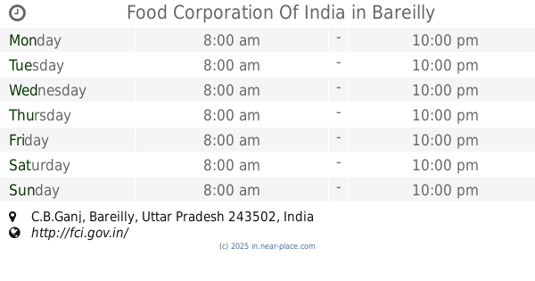
C.B.Ganj, Bareilly, Uttar Pradesh 243502, India
contacts phone
:
+91
Latitude:
28.399754
, Longitude:
79.388516
larger map & directions
read more
nearest Local government office
216 m
Food Corporation Of India
C.B.Ganj, Bareilly
Local government office
read more
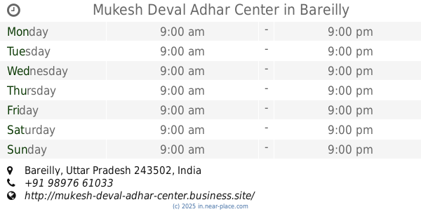
1.629 km
Mukesh Deval Adhar Center
Bareilly
Local government office
read more
2.571 km
Greater Akash Colony
Greater Akash Colony, Karamchari Nagar, Izatnagar, Bareilly
Local government office
read more
2.742 km
Siddarth Nagar
India
Local government office
read more
3.26 km
Rozgar Learning Institute
RP Tower Complex, Hartman Tiraha, Nainital Road, Bareilly
Local government office
read more
3.425 km
Time Office , Diesel Shed Izatanagar
Izatnagar, Bareilly
Local government office
read more
3.559 km
Shiv Estate Colony
State Highway 37, Krishna Nagar, Izatnagar, Bareilly
Local government office
read more
3.644 km
Lokvani Kendra 69 Shanti maurya
Jauharpur
Local government office
read more
3.762 km
Swagat Vihar Colony
India
Local government office
read more
3.952 km
Furnish Edge
H - 7, B.D.A. Colony, Near Tibrinath Mandir, Bareilly
Local government office
read more
3.954 km
Architect Kritya Gangwar
H-7, First Floor, B.D.A. Colony, Near Tibrinath Temple, Bareilly
Local government office
read more
4.23 km
Puspanjali Colony
India
Local government office
read more
4.317 km
Public Works Department Quarter
Rajendra Nagar, Bareilly
Local government office
read more
4.407 km
Regional Passport Office, Bareilly
2nd and 3rd Floor, Vikas Jyoti Commercial Complex, BDA Building, Priyadarshini Nagar, Bareilly
Local government office
read more
4.654 km
Kirti Nagar Colony
Krishna Vanti colony, Bareilly
Local government office
read more
4.702 km
Nishant House Coleney
India
Local government office
read more
4.924 km
GROW Centre
2nd Floor, Ram Murti Lal Tower, Ekta Nagar Chauraha, Stadium Road Bareilly, Bareilly
Local government office
read more
4.988 km
Dr. Reddy's Foundation (GROW Centre)
2nd Floor, Ram Murti Lal Tower, Ekta Nagar Crossing, Stadium Road Near St. Francis School, Opposite Patanjali Mega Store
Local government office
read more
4.989 km
Dr. Reddy's Foundation (GROW Centre)
2nd Floor, Ram Murti Lal Tower, Ekta Nagar Chauraha, Stadium Road Bareilly, Bareilly
Local government office
read more
5.063 km
Sarwar Hussain (Nagar Nigam)
Bhoor, Bareilly
Local government office
read more
5.065 km
U.P. Co-operative Faderation Ltd
Near Galla Mandi, Delapeer Road, Bareilly
Local government office
read more
5.263 km
Kaushambi Enclave
Stadiam Road, City Heart Colony, Bareilly
Local government office
read more
5.514 km
Old Roadways Bareilly
Civil Lines, Bareilly
Local government office
read more
6.523 km
Taj Palace
Shahjahanpur Road, Malion Ki Puliya, Old City, Bareilly
Local government office
read more
6.549 km
Urban Prathmik Swasthya Kendra
Old City, Near Mera Ki Peth, Bareilly
Local government office
read more
📑
all categories
Accounting
Administrative area level 1
Administrative area level 2
Airport
Amusement park
Aquarium
Art gallery
Atm
Bakery
Bank
Bar
Beauty salon
Bicycle store
Book store
Bowling alley
Bus station
Cafe
Campground
Car dealer
Car rental
Car repair
Car wash
Casino
Cemetery
Church
City hall
Clothing store
Colloquial area
Convenience store
Courthouse
Dentist
Department store
Doctor
Electrician
Electronics store
Embassy
Finance
Fire station
Florist
Food
Funeral home
Furniture store
Gas station
General contractor
Grocery or supermarket
Gym
Hair care
Hardware store
Health
Hindu Temple
Home goods store
Hospital
Insurance agency
Intersection
Jewelry store
Laundry
Lawyer
Library
Light rail station
Liquor store
Local government office
Locality
Locksmith
Lodging
Meal delivery
Meal takeaway
Mosque
Movie rental
Movie theater
Moving company
Museum
Natural feature
Neighborhood
Night club
Painter
Park
Parking
Pet store
Pharmacy
Physiotherapist
Place of worship
Plumber
Point of interest
Police
Political
Post office
Premise
Real estate agency
Restaurant
Roofing contractor
Route
Rv park, camping
School
Shoe store
Shopping mall
Spa
Stadium
Storage
Store
Subpremise
Subway station
Supermarket
Synagogue
Taxi stand
Train station
Transit station
Travel agency
University
Veterinary care
Zoo
administrative area level 3
sublocality level 1
sublocality level 2
sublocality level 3
↑