Park nearby Park 12
Coronavirus disease (COVID-19) Situation
confirmed cases
45035393
deaths
533570
India
Park nearby Park 12
Park 12
Stadiam Road, 243005, Bareilly, Bareilly, IN India
contacts phone
:
+91
Latitude:
28.3736
, Longitude:
79.4328
larger map & directions
read more
nearest Park
102 m
Alliance Residency Park
City Heart Colony, Bareilly
Park
read more
227 m
Shahid Bhagat Singh Park
Model Town, Bareilly
Park
read more
429 m
Park
FCI Colony, Stadium Road, Bareilly
Park
read more
463 m
Model Town Park
Guru Govind Singh Nagar, Model Town, Bareilly
Park
read more
602 m
Park 64
Telephone Exchange Residential Colony, Model Town, Bareilly
Park
read more
618 m
Park 61
India
Park
read more
656 m
Park 62
India
Park
read more
690 m
Park 65
B-60, Deen Dayal Puram Road Number 1, Deen Dayal Puram, Bareilly
Park
read more
698 m
Park 66
Deen Dayal Puram, Bareilly
Park
read more
766 m
Rampur garden
2, Stadium Road, Model Town, Haziyapur
Park
read more
785 m
Park 68
India
Park
read more
796 m
Park 69
India
Park
read more
803 m
Park Avas Vikas
Krishna Vanti colony, Bareilly
Park
read more
856 m
Prabhat Nagar Park
Krishna Vanti colony, Bareilly
Park
read more
858 m
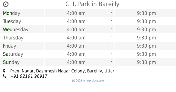
C. I. Park
Prem Nagar, Bareilly
Park
read more
877 m
Dil Shaped Garden
Saket, Prem Nagar, Bareilly
Park
read more
932 m
Mega City Park
mega city, Sanjay Nagar, bypass, Bareilly
Park
read more
985 m
Shivaji Park
Janakpuri, Bareilly
Park
read more
1.022 km
Ahinsa Udyaan
Janakpuri, Bareilly
Park
read more
1.023 km
Park 71
Janakpuri, Bareilly
Park
read more
1.071 km
Tagore Park
C-Block, Rajander Nager, Bareilly
Park
read more
1.214 km
Gole Park
168/3, Dhanvantri Marg, Janakpuri, Bareilly
Park
read more
1.23 km
Janakpuri Park
168/3, Dhanvantri Marg, Janakpuri, Bareilly
Park
read more
1.286 km
Janakpuri Park
India
Park
read more
1.391 km
Janakpuri Tubewell Park
Janakpuri
Park
read more
📑
all categories
Accounting
Administrative area level 1
Administrative area level 2
Airport
Amusement park
Aquarium
Art gallery
Atm
Bakery
Bank
Bar
Beauty salon
Bicycle store
Book store
Bowling alley
Bus station
Cafe
Campground
Car dealer
Car rental
Car repair
Car wash
Casino
Cemetery
Church
City hall
Clothing store
Colloquial area
Convenience store
Courthouse
Dentist
Department store
Doctor
Electrician
Electronics store
Embassy
Finance
Fire station
Florist
Food
Funeral home
Furniture store
Gas station
General contractor
Grocery or supermarket
Gym
Hair care
Hardware store
Health
Hindu Temple
Home goods store
Hospital
Insurance agency
Intersection
Jewelry store
Laundry
Lawyer
Library
Light rail station
Liquor store
Local government office
Locality
Locksmith
Lodging
Meal delivery
Meal takeaway
Mosque
Movie rental
Movie theater
Moving company
Museum
Natural feature
Neighborhood
Night club
Painter
Park
Parking
Pet store
Pharmacy
Physiotherapist
Place of worship
Plumber
Point of interest
Police
Political
Post office
Premise
Real estate agency
Restaurant
Roofing contractor
Route
Rv park, camping
School
Shoe store
Shopping mall
Spa
Stadium
Storage
Store
Subpremise
Subway station
Supermarket
Synagogue
Taxi stand
Train station
Transit station
Travel agency
University
Veterinary care
Zoo
administrative area level 3
sublocality level 1
sublocality level 2
sublocality level 3
↑