Hindu Temple nearby Bandh Baba Mandir
India
Hindu Temple nearby Bandh Baba Mandir
Bandh Baba Mandir
Tata Supervisory Flat, 1no., Gaslitand Colliery Bypass, Sijua India
contacts phone
:
+91
Latitude:
23.7845612
, Longitude:
86.3309084
read more
nearest Hindu Temple
354 m
Radhe Mohan Shiv Hanuman Bhakti Mandir
Tata Supervisory Flat, 1 no 828103, Gaslitand Colliery Bypass, Adarsh Nagari Colony, Sijua
Hindu Temple
read more
450 m
Santoshi Maa Mandir
Bhadrichak
Hindu Temple
read more
744 m
Maa Mansa Mandir
Tata Sijua 6 No
Hindu Temple
read more
789 m
Kaali Mandir
Tata Sijua 6 No
Hindu Temple
read more
803 m
Durga Mandir
Tata Sijua 6 No
Hindu Temple
read more
807 m
Shiv Mandir
Tata Sijua 6 No
Hindu Temple
read more
1.197 km
Shiv Mandir, Saharpura, Sijua
Saharpura
Hindu Temple
read more
1.213 km
Sendra Durga Mandir
Loyabad
Hindu Temple
read more
1.269 km
Hanuman Temple
Tata Supervisory Flat, no6, Gaslitand Colliery Bypass, Sijua
Hindu Temple
read more
1.299 km
Sendra Hanuman Mandir
Loyabad
Hindu Temple
read more
1.375 km
Shitla Mata Temple
Dhanbad
Hindu Temple
read more
1.413 km
काली मंदिर
Dhanbad
Hindu Temple
read more
1.578 km
Hanuman Mandir
Dhanbad
Hindu Temple
read more
1.582 km
Hanuman Temple
Dhanbad Chhatabad Road, Loyabad
Hindu Temple
read more
1.585 km
Durga Mandir
Kantapahari
Hindu Temple
read more
1.754 km
Hanuman Mandir
Basti, Belatand
Hindu Temple
read more
1.826 km
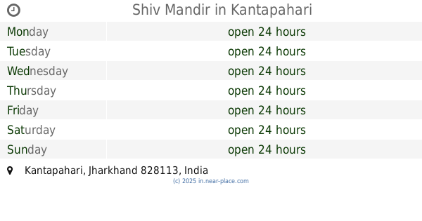
Shiv Mandir
Kantapahari
Hindu Temple
read more
1.894 km
Kaali Mandir
Gaslitand Colliery Bypass, Sijua
Hindu Temple
read more
2.015 km
Hanuman madir
Basti, Belatand
Hindu Temple
read more
2.018 km
Bajrang bali temple
Basti, Belatand
Hindu Temple
read more
2.053 km
Lord Shiva Temple
Bhelatand near TATA Colliery
Hindu Temple
read more
2.091 km
Temple
Belatand
Hindu Temple
read more
2.161 km
Durga Mandir
Bhelatand Colony, Belatand
Hindu Temple
read more
2.249 km
Shiv Mandir
Dhanbad Chhatabad Road, Katras
Hindu Temple
read more
2.344 km
Hanuman Temple
Adarsh Nagari Colony, Belatand
Hindu Temple
read more
📑
all categories
Accounting
Administrative area level 1
Administrative area level 2
Airport
Amusement park
Aquarium
Art gallery
Atm
Bakery
Bank
Bar
Beauty salon
Bicycle store
Book store
Bowling alley
Bus station
Cafe
Campground
Car dealer
Car rental
Car repair
Car wash
Casino
Cemetery
Church
City hall
Clothing store
Colloquial area
Convenience store
Courthouse
Dentist
Department store
Doctor
Electrician
Electronics store
Embassy
Finance
Fire station
Florist
Food
Funeral home
Furniture store
Gas station
General contractor
Grocery or supermarket
Gym
Hair care
Hardware store
Health
Hindu Temple
Home goods store
Hospital
Insurance agency
Intersection
Jewelry store
Laundry
Lawyer
Library
Light rail station
Liquor store
Local government office
Locality
Locksmith
Lodging
Meal delivery
Meal takeaway
Mosque
Movie rental
Movie theater
Moving company
Museum
Natural feature
Neighborhood
Night club
Painter
Park
Parking
Pet store
Pharmacy
Physiotherapist
Place of worship
Plumber
Point of interest
Police
Political
Post office
Premise
Real estate agency
Restaurant
Roofing contractor
Route
Rv park, camping
School
Shoe store
Shopping mall
Spa
Stadium
Storage
Store
Subpremise
Subway station
Supermarket
Synagogue
Taxi stand
Train station
Transit station
Travel agency
University
Veterinary care
Zoo
administrative area level 3
sublocality level 1
sublocality level 2
sublocality level 3
↑