Local government office nearby District Transport Office Kamrup
India
Local government office nearby District Transport Office Kamrup
District Transport Office Kamrup
NH Byepass, Betkuchi, Guwahati India
contacts phone
:
+91
Latitude:
26.1127676
, Longitude:
91.7314507
read more
nearest Local government office
708 m
Public Health Engineering Department
N.H-37 Rd, Gorchuk, Betkuchi, Guwahati
Local government office
read more
815 m
WSSO, Phed, Assam
betkuchi, Guwahati
Local government office
read more
1.05 km
ISBT police Outpost
AHOM GAON, Guwahati
Local government office
read more
1.545 km
SBI Centralized Pension Processing Center
37, National Highway 27, AHOM GAON, Guwahati
Local government office
read more
1.639 km
Central Public Works Department
National Highway 37, Kotabari, Garchuk, Guwahati
Local government office
read more
1.782 km
SR Enterprise
Santipath, Dhirenpara, Guwahati
Local government office
read more
2.084 km
Assam School of Survey and Mandal Training
Raja Nagar Road, Lakshmi Nagar, New Housing Unit, Thanjavur
Local government office
read more
2.089 km
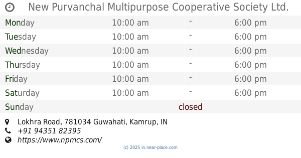
New Purvanchal Multipurpose Cooperative Society Ltd. (NPMCS), Assam
Lokhra Road, Jyotikuchi, Guwahati
Local government office
read more
2.207 km
Office Of The Joint Director Of Surveys, Assam
Sonaighuli, Guwahati
Local government office
read more
2.239 km
Director Of Surveys, Assam
Guwahati,, Sonaighuli, Guwahati
Local government office
read more
2.241 km
ASSTC Campus
781040, Sonaighuli, Guwahati
Local government office
read more
2.61 km
Assam Plantation Crops Development Corporation Limited
National Highway 37, Opposite Sarusajai National Stadium, Sawkuchi, Nalapara, Sarusajai, Guwahati
Local government office
read more
2.701 km
AxomLive
Lal Ganesh, Guwahati
Local government office
read more
3.562 km
Family Court Kamrup
Family court road, Guwahati
Local government office
read more
3.604 km
Vedant Infocare Placement Agency
AK Deb Road, Near Guwahati co operative bank, Guwahati
Local government office
read more
3.616 km
Moran Students' Union Regional Office, Gauhati
DakhinGaon, Guwahati
Local government office
read more
3.724 km
Office Of The Directorat Of Geology & Mining, Assam.
Odalbakra, Kahilipara, Guwahati
Local government office
read more
3.912 km
SLDC , KHP GHY ASSAM
Bongshar, Gopinath Nagar, Jonaknagar, Kahilipara, Guwahati
Local government office
read more
4.269 km
Copy Corner
Netaji Subash Chandra Bose Road, Bhashkar Nagar 4th Lane, Guwahati
Local government office
read more
4.356 km
4th AP BN Police Headquarters
Kahilipara, Guwahati
Local government office
read more
5.269 km
State Council Of Educational Research And Training
Kahilipara Main Road, DPI, Kahilipara, Guwahati
Local government office
read more
5.292 km
Assam Sarba Siksha Abhijan Mission
Kahilipara Road, Kahilipara, Guwahati
Local government office
read more
5.512 km
Directorate of Technical Education, Assam
Kahilipara, Guwahati
Local government office
read more
6.619 km
Passport Seva Kendra
Passport Seva Kendra, Ground and First Floor, Shubham Velocity, Hanuboro, Path, Walford, Guwahati
Local government office
read more
6.677 km
Welkin Visa n Travel
Adam's Plaza, Arunodoi Path, GS Road, Christian Basti, Guwahati
Local government office
read more
📑
all categories
Accounting
Administrative area level 1
Administrative area level 2
Airport
Amusement park
Aquarium
Art gallery
Atm
Bakery
Bank
Bar
Beauty salon
Bicycle store
Book store
Bowling alley
Bus station
Cafe
Campground
Car dealer
Car rental
Car repair
Car wash
Casino
Cemetery
Church
City hall
Clothing store
Colloquial area
Convenience store
Courthouse
Dentist
Department store
Doctor
Electrician
Electronics store
Embassy
Finance
Fire station
Florist
Food
Funeral home
Furniture store
Gas station
General contractor
Grocery or supermarket
Gym
Hair care
Hardware store
Health
Hindu Temple
Home goods store
Hospital
Insurance agency
Intersection
Jewelry store
Laundry
Lawyer
Library
Light rail station
Liquor store
Local government office
Locality
Locksmith
Lodging
Meal delivery
Meal takeaway
Mosque
Movie rental
Movie theater
Moving company
Museum
Natural feature
Neighborhood
Night club
Painter
Park
Parking
Pet store
Pharmacy
Physiotherapist
Place of worship
Plumber
Point of interest
Police
Political
Post office
Premise
Real estate agency
Restaurant
Roofing contractor
Route
Rv park, camping
School
Shoe store
Shopping mall
Spa
Stadium
Storage
Store
Subpremise
Subway station
Supermarket
Synagogue
Taxi stand
Train station
Transit station
Travel agency
University
Veterinary care
Zoo
administrative area level 3
sublocality level 1
sublocality level 2
sublocality level 3
↑