Lodging nearby Gayathri Hotel Kareemabad
India
Lodging nearby Gayathri Hotel Kareemabad
Gayathri Hotel Kareemabad
Vada, Warangal, Telangana 506002, India
contacts phone
:
+91 96760 04285
Latitude:
17.9671861
, Longitude:
79.5922368
larger map & directions
read more
nearest Lodging
129 m
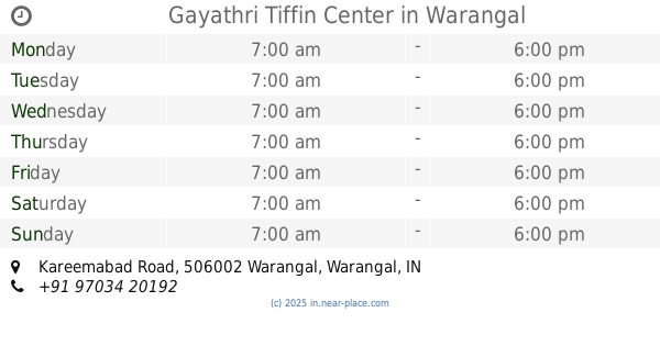
Gayathri Tiffin Center
Kareemabad Road, SRR Thota, Vada, Warangal
Lodging
read more
254 m
Karimabad
Unnamed Road, Vada, Warangal
Lodging
read more
328 m
Ramana Nilayam
Vada, Warangal
Lodging
read more
583 m
Short Stay Home For Women And Girls
House No. 17-3-99, Beside Karimabad Ramasway Devalayam, Kareemabad Road, Kareemabad, Warangal
Lodging
read more
699 m
Vinayaka Hostel
16-4-425/426, Under Bridge Road, Shiva Nagar, Warangal
Lodging
read more
709 m
gemini enterprises
12 Bridge St, Muswellbrook
Lodging
read more
1.119 km
Laxmi Lodge
8-1-88, Old Beet Bazar Road, Old Beet Bazaar, Warangal
Lodging
read more
1.143 km
Azith Tiffen Centre
shop number 8, 2-44, Old Beet Bazar Road, Old Beet Bazaar, Warangal
Lodging
read more
1.163 km
Sammiah Hotel
H.No.16-3-1119, Near Fort Road Petrol Pump, Khammam Road, Ekashila Nagar, Warangal
Lodging
read more
1.176 km
Krishna Bhavan Hotel
Sri Krishna Colony, Old Beet Bazaar, Warangal
Lodging
read more
1.287 km
Gopi Lodge
Krishna College, Station Road, Sri Krishna Colony, Old Beet Bazaar, Warangal
Lodging
read more
1.295 km
Shree Lodge
Under Bridge Road, Sri Krishna Colony, Old Beet Bazaar, Warangal
Lodging
read more
1.318 km
jagadamba hotel
Radhakunj, Old Beet Bazaar, Warangal
Lodging
read more
1.319 km
Raghavendra Lodge
Under Bridge Road, Station Road, Sri Krishna Colony, Girmajipet, Warangal
Lodging
read more
1.396 km
Anand Lodge
H.No. 8-7-215, Beside Head Post Office, Market Street, Old Vegetable Market Road, Station Road, Sri Krishna Colony, Warangal
Lodging
read more
📑
all categories
Accounting
Administrative area level 1
Administrative area level 2
Airport
Amusement park
Aquarium
Art gallery
Atm
Bakery
Bank
Bar
Beauty salon
Bicycle store
Book store
Bowling alley
Bus station
Cafe
Campground
Car dealer
Car rental
Car repair
Car wash
Casino
Cemetery
Church
City hall
Clothing store
Colloquial area
Convenience store
Courthouse
Dentist
Department store
Doctor
Electrician
Electronics store
Embassy
Finance
Fire station
Florist
Food
Funeral home
Furniture store
Gas station
General contractor
Grocery or supermarket
Gym
Hair care
Hardware store
Health
Hindu Temple
Home goods store
Hospital
Insurance agency
Intersection
Jewelry store
Laundry
Lawyer
Library
Light rail station
Liquor store
Local government office
Locality
Locksmith
Lodging
Meal delivery
Meal takeaway
Mosque
Movie rental
Movie theater
Moving company
Museum
Natural feature
Neighborhood
Night club
Painter
Park
Parking
Pet store
Pharmacy
Physiotherapist
Place of worship
Plumber
Point of interest
Police
Political
Post office
Premise
Real estate agency
Restaurant
Roofing contractor
Route
Rv park, camping
School
Shoe store
Shopping mall
Spa
Stadium
Storage
Store
Subpremise
Subway station
Supermarket
Synagogue
Taxi stand
Train station
Transit station
Travel agency
University
Veterinary care
Zoo
administrative area level 3
sublocality level 1
sublocality level 2
sublocality level 3
↑