Lodging nearby The Prem Beacon Hotel
India
Lodging nearby The Prem Beacon Hotel
The Prem Beacon Hotel
Surya Colony, Jodhpur India
contacts phone
:
+91
Latitude:
26.2622468
, Longitude:
73.017541
read more
nearest Lodging
78 m
Khatana Bhawan
Surya Colony, Jodhpur
Lodging
read more
184 m
Dev's Guest House
New Pali Rd, Bhagat Ki Kothi, Jodhpur
Lodging
read more
450 m
The Kamdhenu Inn
B - 34, New Pali Road, Jog Maya Colony, Near Lehariya Sweets, Bhagat Ki Kothi, Jodhpur
Lodging
read more
481 m
western engineers
86, New Power House Road, Section 7 Extension, Shastri Nagar, Jodhpur
Lodging
read more
587 m
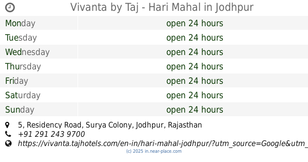
Vivanta Hari Mahal, Jodhpur
5, Residency Road, Jodhpur
Lodging
read more
587 m
Vivanta by Taj - Hari Mahal
5, Residency Road, Jodhpur
Lodging
read more
642 m
Blooming guest house
Surya Colony, Jodhpur
Lodging
read more
676 m
Rukkmani Guest House
Residency Road Nr. Taj Hari Mahal Hotel (Vivanta, Jodhpur
Lodging
read more
692 m
Maa Bhawani Dal Bhati
New Power House Road, Opposite Container Depot, Sector 2, Patrakar Colony, Shastri Nagar, Jodhpur
Lodging
read more
760 m
New Boys Medical Hostel Mdm Campus Jodhpur
292, New Power House Road, Section 7 Extension, Shastri Nagar, Jodhpur
Lodging
read more
843 m
newest UG Boys Hostel
C143, Gali Number 2 Kamla Nehru Colony, Railway Colony, Gali Number 2, Kamla Nehru Colony, Section 7 Extension, Railway Colony, Jodhpur
Lodging
read more
1.033 km
mbm engineering college hostel no 8
Hostel No 8, Ratanada, Jodhpur
Lodging
read more
1.195 km
Dr. S.D.Pandey
Plot No.5&6, Vaishnav Bhawan, Hathiram Ka Oda Road, Kamla Nehru Nagar II, Sri Ganganagar, Jodhpur
Lodging
read more
1.274 km
Sardar Rajput Hostel
Jodhpur
Lodging
read more
1.278 km
Sardar Club Girls Hostel
Air Force Area, Jodhpur
Lodging
read more
📑
all categories
Accounting
Administrative area level 1
Administrative area level 2
Airport
Amusement park
Aquarium
Art gallery
Atm
Bakery
Bank
Bar
Beauty salon
Bicycle store
Book store
Bowling alley
Bus station
Cafe
Campground
Car dealer
Car rental
Car repair
Car wash
Casino
Cemetery
Church
City hall
Clothing store
Colloquial area
Convenience store
Courthouse
Dentist
Department store
Doctor
Electrician
Electronics store
Embassy
Finance
Fire station
Florist
Food
Funeral home
Furniture store
Gas station
General contractor
Grocery or supermarket
Gym
Hair care
Hardware store
Health
Hindu Temple
Home goods store
Hospital
Insurance agency
Intersection
Jewelry store
Laundry
Lawyer
Library
Light rail station
Liquor store
Local government office
Locality
Locksmith
Lodging
Meal delivery
Meal takeaway
Mosque
Movie rental
Movie theater
Moving company
Museum
Natural feature
Neighborhood
Night club
Painter
Park
Parking
Pet store
Pharmacy
Physiotherapist
Place of worship
Plumber
Point of interest
Police
Political
Post office
Premise
Real estate agency
Restaurant
Roofing contractor
Route
Rv park, camping
School
Shoe store
Shopping mall
Spa
Stadium
Storage
Store
Subpremise
Subway station
Supermarket
Synagogue
Taxi stand
Train station
Transit station
Travel agency
University
Veterinary care
Zoo
administrative area level 3
sublocality level 1
sublocality level 2
sublocality level 3
↑