Park nearby Karpoorapu Devi Chaitanya Childrens Park
India
Park nearby Karpoorapu Devi Chaitanya Childrens Park
Karpoorapu Devi Chaitanya Childrens Park
Venkata Ramana Colony, NGO Colony, Guntur India
contacts phone
:
+91
Latitude:
16.3015134
, Longitude:
80.4106602
read more
nearest Park
314 m
NGO Colony Park
Pattabhipuram AT Agraharam Road, NGO Colony, Guntur
Park
read more
337 m
NGO's Colony Park
APHB Colony, Guntur
Park
read more
748 m
Housing Board Colony Park
APHB Colony, Guntur
Park
read more
1.072 km
Shyamala Nagar Park
Syamala Nagar
Park
read more
1.457 km
Annamayya Park
Brindavan Gardens, Guntur
Park
read more
1.462 km
Vishnu's Park
Brindavan Gardens, Guntur
Park
read more
1.589 km
Krishna Nagar Municipal Park
Krishna Nagar Main Road, Ashok Nagar, Guntur
Park
read more
1.596 km
Tall Plaza
A T Agraharam Road, AT Agraharam, Guntur
Park
read more
1.882 km
Nalanda Nagar Park
Rajendra Nagar North
Park
read more
2.099 km
Gujjanagundla park
Gujjanagundla Walking Track, SVN Colony, Guntur
Park
read more
2.2 km
Rail Eco Park
Nallapadu Rural
Park
read more
2.503 km
Vidyanagar Park
Vidyanagar, Guntur
Park
read more
2.544 km
Satya Park
Vikas Nagar, Guntur
Park
read more
2.556 km
G M C Childrens Park
Vikas Nagar
Park
read more
2.584 km
Brodipet Park
Brodipet, Guntur
Park
read more
2.697 km
Gayatri Plaza
Koritepadu Road, Lakshmipuram, Ashok Nagar, Guntur
Park
read more
2.707 km
MVNR Plaza
4th Lane, Brodipet, Guntur
Park
read more
2.727 km
Koritepadu Park
Lakshmipuram
Park
read more
2.782 km
Paradise Plaza
Koritepadu Road, Koritepadu, Guntur
Park
read more
2.852 km
KARUNYA GARDENS
Brodipet, Guntur
Park
read more
2.946 km
Louis Pasteur Garden
Kanna Vari Thota
Park
read more
2.947 km
Lotus Fountain
Kanna Vari Thota
Park
read more
2.957 km
SVN Colony Park
SVN Colony Park Track, SVN Colony, Guntur
Park
read more
3.061 km
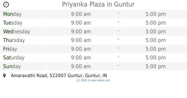
Priyanka Plaza
Amaravathi Road, Vishnu Nagar, Koritepadu, Guntur
Park
read more
3.125 km
Sampath Nagar Municipal Park
Sampath Nagar, Guntur
Park
read more
📑
all categories
Accounting
Administrative area level 1
Administrative area level 2
Airport
Amusement park
Aquarium
Art gallery
Atm
Bakery
Bank
Bar
Beauty salon
Bicycle store
Book store
Bowling alley
Bus station
Cafe
Campground
Car dealer
Car rental
Car repair
Car wash
Casino
Cemetery
Church
City hall
Clothing store
Colloquial area
Convenience store
Courthouse
Dentist
Department store
Doctor
Electrician
Electronics store
Embassy
Finance
Fire station
Florist
Food
Funeral home
Furniture store
Gas station
General contractor
Grocery or supermarket
Gym
Hair care
Hardware store
Health
Hindu Temple
Home goods store
Hospital
Insurance agency
Intersection
Jewelry store
Laundry
Lawyer
Library
Light rail station
Liquor store
Local government office
Locality
Locksmith
Lodging
Meal delivery
Meal takeaway
Mosque
Movie rental
Movie theater
Moving company
Museum
Natural feature
Neighborhood
Night club
Painter
Park
Parking
Pet store
Pharmacy
Physiotherapist
Place of worship
Plumber
Point of interest
Police
Political
Post office
Premise
Real estate agency
Restaurant
Roofing contractor
Route
Rv park, camping
School
Shoe store
Shopping mall
Spa
Stadium
Storage
Store
Subpremise
Subway station
Supermarket
Synagogue
Taxi stand
Train station
Transit station
Travel agency
University
Veterinary care
Zoo
administrative area level 3
sublocality level 1
sublocality level 2
sublocality level 3
↑