Park nearby Lions Park
India
Park nearby Lions Park
Lions Park
Gumanpura, Kota Indien
contacts phone
:
+91
Latitude:
25.1862728
, Longitude:
75.8462291
read more
nearest Park
256 m
Lucky Burj
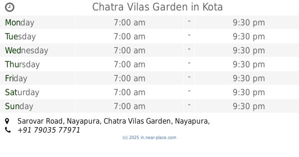
Chatra Vilas Garden, Nayapura, Kota
Park
read more
315 m
Naga Ji Ka Bag
Chatra Vilas Garden, Nayapura, Kota
Park
read more
348 m
Nag Ji Garden
Chatra Vilas Garden, Nayapura, Kota
Park
read more
458 m
Gopal Nivas Baag
Chatra Vilas Garden, Nayapura, Kota
Park
read more
467 m
Mahatma Gandhi Park
Rampura
Park
read more
659 m
Chatra Vilas Garden
Sarovar Road, Nayapura, Kota
Park
read more
667 m
Baaradari Indrasan
Sarovar Road, Chatra Vilas Garden, Nayapura, Kota
Park
read more
727 m
Seven Wonders Park
Ballabhbari
Park
read more
730 m
C B Garden
Unnamed Road, Chatra Vilas Garden, Nayapura, Kota
Park
read more
761 m
chatrvilas garden , Nayapura Kota
Kota, Chatra Vilas Garden, Nayapura, Kota
Park
read more
863 m
Seven Wonders
Kotri Mini Flyover, Ballabhbari, Gaytri Vihar, Kota
Park
read more
863 m
Seven Wonders Park
Kotri Mini Flyover, Ballabhbari, Gaytri Vihar, Kota
Park
read more
970 m
Shri Guru Govind Singh Park
Nagar Vikas Nyas, Ballabhbari, Kota
Park
read more
984 m
Desert Park
Chatra Vilas Garden, Nayapura, Kota
Park
read more
987 m
Nayapura Park
Nayapura, Kota
Park
read more
1.129 km
Maharshi Dhadhich Garden
Gaytri Vihar, Kota
Park
read more
1.259 km
park
Nayapura, Kota
Park
read more
1.504 km
Bhawani Park
Kunadi, Electricity Board Area, Kota
Park
read more
1.55 km
Park
UIT Scheme Sakatpura, Kota Thermal Power Station Colony, Electricity Board Area, Kota
Park
read more
1.578 km
Sant Namdev Bhawan
Patanpol, Rampura, Kota
Park
read more
1.794 km
Pandit DeenDayal Uppadhya Park
Barrage Road, Tipta, Kota
Park
read more
1.799 km
Thichona Park
Ticona Park, Gumanpura, Kota
Park
read more
1.829 km
Sabarmati Colony Park
Retwali
Park
read more
1.83 km
Sabarmati Colony Park
Kota,, Retwali, Rampura, Kota
Park
read more
1.964 km
Mahaveer Park
Rajbhavan road civil line, Kota
Park
read more
📑
all categories
Accounting
Administrative area level 1
Administrative area level 2
Airport
Amusement park
Aquarium
Art gallery
Atm
Bakery
Bank
Bar
Beauty salon
Bicycle store
Book store
Bowling alley
Bus station
Cafe
Campground
Car dealer
Car rental
Car repair
Car wash
Casino
Cemetery
Church
City hall
Clothing store
Colloquial area
Convenience store
Courthouse
Dentist
Department store
Doctor
Electrician
Electronics store
Embassy
Finance
Fire station
Florist
Food
Funeral home
Furniture store
Gas station
General contractor
Grocery or supermarket
Gym
Hair care
Hardware store
Health
Hindu Temple
Home goods store
Hospital
Insurance agency
Intersection
Jewelry store
Laundry
Lawyer
Library
Light rail station
Liquor store
Local government office
Locality
Locksmith
Lodging
Meal delivery
Meal takeaway
Mosque
Movie rental
Movie theater
Moving company
Museum
Natural feature
Neighborhood
Night club
Painter
Park
Parking
Pet store
Pharmacy
Physiotherapist
Place of worship
Plumber
Point of interest
Police
Political
Post office
Premise
Real estate agency
Restaurant
Roofing contractor
Route
Rv park, camping
School
Shoe store
Shopping mall
Spa
Stadium
Storage
Store
Subpremise
Subway station
Supermarket
Synagogue
Taxi stand
Train station
Transit station
Travel agency
University
Veterinary care
Zoo
administrative area level 3
sublocality level 1
sublocality level 2
sublocality level 3
↑