Park nearby Public Park 3
India
Park nearby Public Park 3
Public Park 3
Sector 23B, Sector 23, Chandigarh India
contacts phone
:
+91
Latitude:
30.738565
, Longitude:
76.7699078
read more
nearest Park
198 m
Public Park
22A
Park
read more
579 m
Abdul Kalam Azaad Park
22A, Sector 22, Chandigarh
Park
read more
596 m
Nehru Park
Shastri Market Rd, 22B, Sector 22, Chandigarh
Park
read more
596 m
Nehru Park
Shastri Market Rd, sector 22 B, Chandigarh
Park
read more
615 m
VIP Fountain park
22A, Sector 22, Chandigarh
Park
read more
659 m
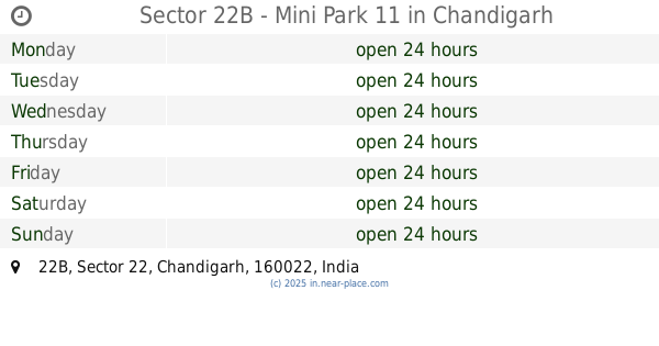
Sector 22B - Mini Park 11
22B, Chandigarh
Park
read more
730 m
Moonlit Park
17G, Sector 22D, Chandigarh
Park
read more
742 m
Park 9
22B, Sector 22, Chandigarh
Park
read more
747 m
Park 3
Sector 22B, Chandigarh
Park
read more
751 m
Sector 22B Park 10
22B, Chandigarh
Park
read more
772 m
Sector 22B - Mini Park 2
22B, Chandigarh
Park
read more
828 m
Park 4
1405, Himalaya Marg, 22B, Sector 22, Chandigarh
Park
read more
854 m
Sector 22B Mini Park 8
22B, Sector 22, Chandigarh
Park
read more
856 m
Sector 22B - Mini Park 5
22B, Chandigarh
Park
read more
889 m
Sector 22B Park 1
22B, Sector 22-B, Chandigarh
Park
read more
889 m
Sector 22B - Mini Park 7
22B, Chandigarh
Park
read more
890 m
Park 6
22B, Sector 22, Chandigarh
Park
read more
963 m
Matka Park
22C, Sector 22, Chandigarh
Park
read more
973 m
Green Belt
Sector 17
Park
read more
994 m
Sector 22D Park
Sector 22D, Chandigarh
Park
read more
1.016 km
Park 40
Sector 24B, Udyan Path, Sector 24, Chandigarh
Park
read more
1.034 km
Mini Park - Sector 22B
Udyog Path, 22B, Sector 22, Chandigarh
Park
read more
1.093 km
Park 30
Sector 24B, Udyan Path, Sector 24, Chandigarh
Park
read more
1.191 km
Mini Rose Garden
24A, Sector 24, Chandigarh
Park
read more
1.88 km
park
Sector 34B
Park
read more
📑
all categories
Accounting
Administrative area level 1
Administrative area level 2
Airport
Amusement park
Aquarium
Art gallery
Atm
Bakery
Bank
Bar
Beauty salon
Bicycle store
Book store
Bowling alley
Bus station
Cafe
Campground
Car dealer
Car rental
Car repair
Car wash
Casino
Cemetery
Church
City hall
Clothing store
Colloquial area
Convenience store
Courthouse
Dentist
Department store
Doctor
Electrician
Electronics store
Embassy
Finance
Fire station
Florist
Food
Funeral home
Furniture store
Gas station
General contractor
Grocery or supermarket
Gym
Hair care
Hardware store
Health
Hindu Temple
Home goods store
Hospital
Insurance agency
Intersection
Jewelry store
Laundry
Lawyer
Library
Light rail station
Liquor store
Local government office
Locality
Locksmith
Lodging
Meal delivery
Meal takeaway
Mosque
Movie rental
Movie theater
Moving company
Museum
Natural feature
Neighborhood
Night club
Painter
Park
Parking
Pet store
Pharmacy
Physiotherapist
Place of worship
Plumber
Point of interest
Police
Political
Post office
Premise
Real estate agency
Restaurant
Roofing contractor
Route
Rv park, camping
School
Shoe store
Shopping mall
Spa
Stadium
Storage
Store
Subpremise
Subway station
Supermarket
Synagogue
Taxi stand
Train station
Transit station
Travel agency
University
Veterinary care
Zoo
administrative area level 3
sublocality level 1
sublocality level 2
sublocality level 3
↑