Place of worship nearby Jain Mandir Vrindavan Society
India
Place of worship nearby Jain Mandir Vrindavan Society
Jain Mandir Vrindavan Society
5, NS Mankikar Road, Krishnalaya Society, Vrindavan, Chunabhatti, Sion, Mumbai India
contacts phone
:
+91
Latitude:
19.051456
, Longitude:
72.868205
read more
nearest Place of worship
537 m
Vurjevandas Sanitarium
14, NS Mankikar Rd Sion Railway Colony, Sion East, NS Mankikar Road, Sion Railway Colony, Sion East, Sion, Mumbai
Place of worship
read more
1.583 km
Shree Digambar Jain Mandir Kurla West
Jama Masjid Lane, Kurla West, Kurla, Mumbai
Place of worship
read more
2.078 km
Shree Pimpaleshwar Hanuman Mandir
Near Kurla Station Bus Stop, Kurla Station, C.S.T. Road, Brahmanwadi, Kurla, Mumbai
Place of worship
read more
2.098 km
Munisuvratswami Jain Mandir
New Mills Rd, Kurla West, Mumbai
Place of worship
read more
2.101 km
Jain Temple Mahavir bhagvan
New Mill Road, Kurla West, Kurla, Mumbai
Place of worship
read more
2.158 km
Afzal Box Wala
Kurla West,, Brahmanwadi, Kurla West, Mumbai
Place of worship
read more
2.235 km
Shri Jain Terapanth Bhavan, Kurla West
Hari Niwas CHS, Lal Bahadur Shastri Road, Kurla West, Kurla, Mumbai
Place of worship
read more
2.286 km
Shree Paramhans Ashram Kurla West
4, Sarveshwar Mandir Road, Chhadva Nagar, Kurla West, Kurla, Mumbai
Place of worship
read more
2.476 km
ARULMIGU VARAM MANDIR
Shammi Nagar, Dharavi, Mumbai
Place of worship
read more
2.477 km
Darbar-e-Samandari Baba RH
Ambedkar Nagar, Kurla West, Kurla, Mumbai
Place of worship
read more
2.504 km
Pjya Shwetambar Manipada Jain Mandir
WING A, Manipada Road, Kolivery Village, Vidya Nagari, Kalina, Santacruz East, Mumbai
Place of worship
read more
2.628 km
Shree Harigurugram (SHGG)
New English School ,, New English School Marg, Government Colony, Near Kherwadi Police Station, Bandra East, Mumbai
Place of worship
read more
2.636 km
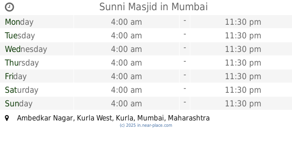
Sunni Masjid
Ambedkar Nagar, Kurla West, Kurla, Mumbai
Place of worship
read more
2.79 km
Amrapali Buddha Vihar
Near C.S.T. Road, SG Barve Marg, Ambedkar Nagar, Kurla, Mumbai
Place of worship
read more
2.822 km
Holy Cross Guild Chapel
Vidya Nagari
Place of worship
read more
2.854 km
Gurdwara Guru Nanak Punjabi Darbar
LBS Road, Central Salsette Tramway Road, Kapadia Nagar, Kurla, Mumbai
Place of worship
read more
2.871 km
Gurudwara Dashmesh Darbar Kalina
44, Jogiraj Ashram Lane, Kolivery Village, Mathuradas Colony, Vakola, Santacruz East, Mumbai
Place of worship
read more
2.979 km
Guru Nanak Satsang Kalina Gurudwara
Lotus Lane, Opp. Bombay College Of Pharmacy, Sunder Nagar, Kalina, Santacruz East, Mumbai
Place of worship
read more
3.205 km
Buddh Vihar Mandir
Near Sarvoday Buddhist Temple, Sarvoday Mahadudh Vihar, Sarvoday Buddh Vihar Road, Tansa Pipeline Road, Tilak Nagar, Kurla East, Mumbai
Place of worship
read more
3.588 km
Shree Adinath Shwetambar Jain Mandir
Neelkanth Vihar Complex, Tansa Pipeline Road, New Tilak Nagar, Mumbai
Place of worship
read more
3.661 km
Apartment cross
Kurla West, Christian Gaon, Kurla West, Mumbai
Place of worship
read more
3.883 km
KURLA GAOTHAN VILLAGE CROSS
81, Father Peter Pereira Road, Christian Gaon, Kurla, Mumbai
Place of worship
read more
4.035 km
Marumata Temple
1, 1, Nagesh Patilwadi, Chembur East, Mumbai
Place of worship
read more
4.613 km
Shri Digambar Jain Mandir, Khar
Khar Road, Badi, Malad West, Mumbai
Place of worship
read more
5.467 km
Vasupujyaswami Jain Ghar Derasar
C Wing, Manali Apartment, Himalaya Society, Milind Nagar, Ghatkopar West, Mumbai
Place of worship
read more
📑
all categories
Accounting
Administrative area level 1
Administrative area level 2
Airport
Amusement park
Aquarium
Art gallery
Atm
Bakery
Bank
Bar
Beauty salon
Bicycle store
Book store
Bowling alley
Bus station
Cafe
Campground
Car dealer
Car rental
Car repair
Car wash
Casino
Cemetery
Church
City hall
Clothing store
Colloquial area
Convenience store
Courthouse
Dentist
Department store
Doctor
Electrician
Electronics store
Embassy
Finance
Fire station
Florist
Food
Funeral home
Furniture store
Gas station
General contractor
Grocery or supermarket
Gym
Hair care
Hardware store
Health
Hindu Temple
Home goods store
Hospital
Insurance agency
Intersection
Jewelry store
Laundry
Lawyer
Library
Light rail station
Liquor store
Local government office
Locality
Locksmith
Lodging
Meal delivery
Meal takeaway
Mosque
Movie rental
Movie theater
Moving company
Museum
Natural feature
Neighborhood
Night club
Painter
Park
Parking
Pet store
Pharmacy
Physiotherapist
Place of worship
Plumber
Point of interest
Police
Political
Post office
Premise
Real estate agency
Restaurant
Roofing contractor
Route
Rv park, camping
School
Shoe store
Shopping mall
Spa
Stadium
Storage
Store
Subpremise
Subway station
Supermarket
Synagogue
Taxi stand
Train station
Transit station
Travel agency
University
Veterinary care
Zoo
administrative area level 3
sublocality level 1
sublocality level 2
sublocality level 3
↑