Place of worship nearby Milind Buddha Vihar
India
Place of worship nearby Milind Buddha Vihar
Milind Buddha Vihar
313, 313, Nagpur India
contacts phone
:
+91
Latitude:
21.134025
, Longitude:
79.0941579
read more
nearest Place of worship
135 m
Buddha Vihar
Medical Road, Yayenti Ground, Rambagh, Nagpur
Place of worship
read more
233 m
Ashoka Buddha Viahar
Imamwada, Nagpur
Place of worship
read more
465 m
Tajjudin Baba Darga
Great Ghat Road, Near Imamvada, Imamvada, Rambagh, Nagpur
Place of worship
read more
468 m
Shiv Mandir
Medical Road, Indira Nagar, Rambagh, Nagpur
Place of worship
read more
771 m
Ganpati Mandir
Medical College Road, Medical Chowk, Chandan Nagar, Nagpur
Place of worship
read more
1.001 km
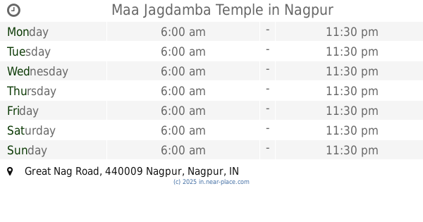
Maa Jagdamba Temple
Great Nag Road, Siraspeth, Nagpur
Place of worship
read more
1.17 km
Bajarangbali Devsthan
Subhash Road, Agyaram Devi Square, Empress City, Nagpur
Place of worship
read more
1.179 km
Shree Maroti Devasthan
Abhyankar Marg, Dhantoli, Nagpur
Place of worship
read more
1.273 km
Shri Datt Printers
Subhash Road, Cotton Market, Subhash Nagar, Empress City, Nagpur
Place of worship
read more
1.294 km
Jai Jhulelal Mandir
Subhash Road, Raman Vighan Kandhara, Agharam Devi, Empress City, Nagpur
Place of worship
read more
1.308 km
Ganesh Mandir
Subhash Road, Cotton Market, Empress City, Nagpur
Place of worship
read more
1.37 km
Jay Mata Di
Mata Mandir, Anand Nagar, Sitabuldi, Nagpur
Place of worship
read more
1.396 km
Maa Durga Pooja Bhandar
Gulli No.3, Shop No 40, Nr. Kanji House , Mahatma Phule Market, Nagpur
Place of worship
read more
1.4 km
Shri Sai Mandir
Guru Teg Bahadur Marg, Cotton Market, Mahatma Fule Bazar, Empress City, Nagpur
Place of worship
read more
1.45 km
Shishu Spandan Convent
Plot no.71 Rambagh layout medical chock Nagpur, Nagpur
Place of worship
read more
1.618 km
Hindu Gnyanpith Convent
Ram Mandir Ln, Gandhi Sagar, Nagpur
Place of worship
read more
1.647 km
Seth Billimoria Brothers Dharamshala
Opp Gandhi Sagar Lake, Near Tata Parsi School, Ganeshpeth, Empress City, Nagpur
Place of worship
read more
1.656 km
Parsi Agyari
89/B, 89/B, Nagpur
Place of worship
read more
1.857 km
Wagh Bhavan
Soni Lane, Sitabuldi, Nagpur
Place of worship
read more
1.87 km
Om Nagdwar Swami Prasanna
Ayachit Road, Near Digamber Temple, Reshim Bagh, Nagpur
Place of worship
read more
1.875 km
Shri Parshvanath Digambar Khandelwal Jain Mandir
Ayachit Rd,Sakkardara Road, Juni Shukrawari, Reshim Bagh, Nagpur
Place of worship
read more
1.889 km
Dhigambar Jain Mandir
Sakkardara Road, Near Gandhi Putla , Juni Shukrawari, Ganesh Nagar, Reshim Bagh, Nagpur
Place of worship
read more
1.984 km
Sadbhavna Mandir
Wanjari Nagar, Ajni Medical Colony, Dhantoli, Nagpur
Place of worship
read more
2.26 km
Prabodhan Convent
Ayachit Rd, Nana Saheb Shastri Road, Opp Bank Of India, Mangalwari, Mahal, Nagpur
Place of worship
read more
2.395 km
Tajruddin Dargah
BSNL Office, Civil Lines, Nagpur
Place of worship
read more
📑
all categories
Accounting
Administrative area level 1
Administrative area level 2
Airport
Amusement park
Aquarium
Art gallery
Atm
Bakery
Bank
Bar
Beauty salon
Bicycle store
Book store
Bowling alley
Bus station
Cafe
Campground
Car dealer
Car rental
Car repair
Car wash
Casino
Cemetery
Church
City hall
Clothing store
Colloquial area
Convenience store
Courthouse
Dentist
Department store
Doctor
Electrician
Electronics store
Embassy
Finance
Fire station
Florist
Food
Funeral home
Furniture store
Gas station
General contractor
Grocery or supermarket
Gym
Hair care
Hardware store
Health
Hindu Temple
Home goods store
Hospital
Insurance agency
Intersection
Jewelry store
Laundry
Lawyer
Library
Light rail station
Liquor store
Local government office
Locality
Locksmith
Lodging
Meal delivery
Meal takeaway
Mosque
Movie rental
Movie theater
Moving company
Museum
Natural feature
Neighborhood
Night club
Painter
Park
Parking
Pet store
Pharmacy
Physiotherapist
Place of worship
Plumber
Point of interest
Police
Political
Post office
Premise
Real estate agency
Restaurant
Roofing contractor
Route
Rv park, camping
School
Shoe store
Shopping mall
Spa
Stadium
Storage
Store
Subpremise
Subway station
Supermarket
Synagogue
Taxi stand
Train station
Transit station
Travel agency
University
Veterinary care
Zoo
administrative area level 3
sublocality level 1
sublocality level 2
sublocality level 3
↑