Police nearby Purana Quilla Police Station
Coronavirus disease (COVID-19) Situation
confirmed cases
45035393
deaths
533570
India
Police nearby Purana Quilla Police Station
Purana Quilla Police Station
Husainganj, Lucknow India
contacts phone
:
+91
Latitude:
26.833324
, Longitude:
80.9409946
read more
nearest Police
146 m
Purana Quila Police Chowki
12/30, Cantonment Road, Purana Quilla, Khatkeyana, Lucknow
Police
read more
508 m
Kotwali Hussainganj
J.N. Road, Husainganj, Lucknow
Police
read more
508 m
Husainganj Police Station
12/52, Cantonment Road, Udaiganj, Husainganj, Lucknow
Police
read more
654 m
Traffic Police Line
22-27, Mangal Pande Marg, Neil Lines, Cantonment, Lucknow
Police
read more
832 m
Uttar Pradesh Police Recruitment And Promotion Board
10 C, Sheetal Complex, Vidhan Sabha Marg, Lucknow
Police
read more
864 m
Police Help Center
Husainganj Choraha, Lucknow
Police
read more
904 m
Headquarter Eastern Frontier (I.t.b.p.)
19 B, Sheetal Complex, Vidhan Sabha Marg, Lucknow
Police
read more
1.012 km
police chawki chitwapur
Guru Gobindsingh Marg, Naka Hindola, Lucknow
Police
read more
1.025 km
Old Loco Chawki
Cantonment, Lucknow
Police
read more
1.028 km
Police Chowki
Gulistan Colony,, 1A, Vivekanand Marg, Bandariya Bag Railway Colony, Gulistan Colony, Cantonment, Lucknow
Police
read more
1.131 km
Police Cheak Post
21, Vikramaditya Marg, Christian Colony, Bandariya Bag Railway Colony, Gulistan Colony, Lucknow
Police
read more
1.177 km
Police Station
98, Park Road, गोसांईगंज, Raj Bhavan Colony, Lalbagh, Lucknow
Police
read more
1.262 km
Police Chowki Khandari Bazar
Kotawali Kaiserbagh, Odean Cinema Ki Dhal, Fool Bagh, Nipendra Sanyal, Burlington Colony, Aminabad, Lucknow
Police
read more
1.306 km
Gautam Palli Police Station Lko
21, Vikramaditya Marg, Christian Colony, Gulistan Colony, Lucknow
Police
read more
1.497 km
Traffic Police Booth Park Road
Park Road, Park Road, Near Ambedkar Murti, Hazratganj, Lucknow
Police
read more
1.562 km
Rajkiya Railway Police
Station Road, Railway Colony, Charbagh, Lucknow
Police
read more
1.598 km
Police Chowki Hazratganj Bildari Lane
Bildari Lane, Bildari Lane, Near Novelty Cinema, Lalbagh, Lucknow
Police
read more
1.657 km
POLICE ASSISTANCE BOOTH
CHARBAG RAILWAY STATION, Charbagh, Lucknow
Police
read more
1.686 km
J.R.P & R.P.F-R.P.C
Railway Station, Charbagh, Lucknow
Police
read more
1.722 km
Police Station Chowki 8911 Old RTO
89/11, Old RTO, 89/11, Old RTO, Gautam .Budh . Marg, Shimla Hotel, Gautam Budh Marg, Lucknow
Police
read more
1.808 km
Police Chauki
Gautam Budh Marg, Gautam Budh Marg, Baasmandi, Aminabad, Lucknow
Police
read more
1.85 km
Police Station
Preeti Nagar, Railway Colony, Charbagh, Lucknow
Police
read more
1.905 km
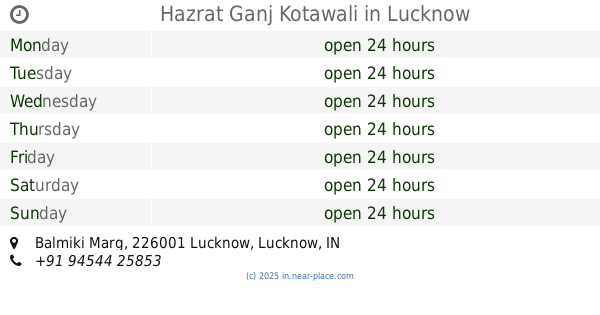
Hazrat Ganj Kotawali
Balmiki Marg, DM Compound Colony, Kaiserbagh Officer's Colony, Lalbagh, Lucknow
Police
read more
2.013 km
Aminabad Police Station
Shri Ram Road, Aminabad, Lucknow
Police
read more
2.107 km
Police Chowki, Narhi
Ramtirth Marg, Narhi, Hazratganj, Lucknow
Police
read more
📑
all categories
Accounting
Administrative area level 1
Administrative area level 2
Airport
Amusement park
Aquarium
Art gallery
Atm
Bakery
Bank
Bar
Beauty salon
Bicycle store
Book store
Bowling alley
Bus station
Cafe
Campground
Car dealer
Car rental
Car repair
Car wash
Casino
Cemetery
Church
City hall
Clothing store
Colloquial area
Convenience store
Courthouse
Dentist
Department store
Doctor
Electrician
Electronics store
Embassy
Finance
Fire station
Florist
Food
Funeral home
Furniture store
Gas station
General contractor
Grocery or supermarket
Gym
Hair care
Hardware store
Health
Hindu Temple
Home goods store
Hospital
Insurance agency
Intersection
Jewelry store
Laundry
Lawyer
Library
Light rail station
Liquor store
Local government office
Locality
Locksmith
Lodging
Meal delivery
Meal takeaway
Mosque
Movie rental
Movie theater
Moving company
Museum
Natural feature
Neighborhood
Night club
Painter
Park
Parking
Pet store
Pharmacy
Physiotherapist
Place of worship
Plumber
Point of interest
Police
Political
Post office
Premise
Real estate agency
Restaurant
Roofing contractor
Route
Rv park, camping
School
Shoe store
Shopping mall
Spa
Stadium
Storage
Store
Subpremise
Subway station
Supermarket
Synagogue
Taxi stand
Train station
Transit station
Travel agency
University
Veterinary care
Zoo
administrative area level 3
sublocality level 1
sublocality level 2
sublocality level 3
↑