Restaurant nearby Bapu Alupapad Bryani
India
Restaurant nearby Bapu Alupapad Bryani
Bapu Alupapad Bryani
Shahibag, Ahmedabad India
contacts phone
:
+91
Latitude:
23.0503718
, Longitude:
72.5871014
read more
nearest Restaurant
619 m
Joya bhathiyaar khana
pani taki pase, Dudeshwar, Ahmedabad
Restaurant
read more
1.004 km
Burger Corner
8, malinath complex ,opp. Sujata flats, Shahibaug, Ahmedabad
Restaurant
read more
1.21 km
R. V. SNACKS PARLOUR
Rabarivas, Old Wadaj, Ahmedabad
Restaurant
read more
1.571 km
Cafe 15 A - St Laurn Towers
St Laurn Towers, 15, Ashram Road, Old Wadaj, Ashram Road
Restaurant
read more
1.582 km
green iris k k nagar road
Regenta Hotel,, Old Wadaj, Ahmedabad
Restaurant
read more
1.62 km
Bhagvati Bhajiya House
Dandi Kuch Circle, Thakor Vas, Sardar Colony, Ahmedabad
Restaurant
read more
1.62 km
Shree Arbuda Dalbati
Opp Wadaj Circle, Ashram Road, Old Wadaj, Ahmedabad
Restaurant
read more
1.624 km
Gurukrupa Bhojnalaya
Opp Wadaj Circle, Ashram Road, Old Wadaj, Ahmedabad
Restaurant
read more
1.639 km
Ambica Fast Food
Nr Juna Wadaj Police Choki, Opp. Juna Wadaj Bus Stop, Ashram Road, Juna Wadaj, Ahmedabad
Restaurant
read more
1.651 km
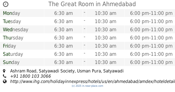
The Great Room
Ashram Road, Satyawadi Society, Usman Pura, Ahmedabad
Restaurant
read more
1.691 km
Yamuna Parlour & Snacks
21/A SUKHSAGAR COMPLEX , USMANPURA,NEAR FORTUNE LANDMARK, ASHRAM ROAD, Ahmedabad
Restaurant
read more
1.86 km
Chalte Chalte
Ashram Road, Near Usmanpura Cross Road, Ashram Road, Ahmedabad
Restaurant
read more
2.006 km
Gayatri Bhajipav & Chinese Fastfood
Below Shwetal Apartment Opp Shahfatha Masjid Bahai Centre Shahpur, Shahpur, Ahmedabad
Restaurant
read more
2.308 km
Tasty Puri Shak
Behind Felowship School, Opposite Popular House, Dinesh Hall Road, Ashram Road, Shreyas Colony, Navrangpura, Ahmedabad
Restaurant
read more
2.401 km
Bright Chef Restarurant
64/5, Vishal Commercial Centre, Ashram Road, Navrangpura, Navrangpura, Ahmedabad
Restaurant
read more
📑
all categories
Accounting
Administrative area level 1
Administrative area level 2
Airport
Amusement park
Aquarium
Art gallery
Atm
Bakery
Bank
Bar
Beauty salon
Bicycle store
Book store
Bowling alley
Bus station
Cafe
Campground
Car dealer
Car rental
Car repair
Car wash
Casino
Cemetery
Church
City hall
Clothing store
Colloquial area
Convenience store
Courthouse
Dentist
Department store
Doctor
Electrician
Electronics store
Embassy
Finance
Fire station
Florist
Food
Funeral home
Furniture store
Gas station
General contractor
Grocery or supermarket
Gym
Hair care
Hardware store
Health
Hindu Temple
Home goods store
Hospital
Insurance agency
Intersection
Jewelry store
Laundry
Lawyer
Library
Light rail station
Liquor store
Local government office
Locality
Locksmith
Lodging
Meal delivery
Meal takeaway
Mosque
Movie rental
Movie theater
Moving company
Museum
Natural feature
Neighborhood
Night club
Painter
Park
Parking
Pet store
Pharmacy
Physiotherapist
Place of worship
Plumber
Point of interest
Police
Political
Post office
Premise
Real estate agency
Restaurant
Roofing contractor
Route
Rv park, camping
School
Shoe store
Shopping mall
Spa
Stadium
Storage
Store
Subpremise
Subway station
Supermarket
Synagogue
Taxi stand
Train station
Transit station
Travel agency
University
Veterinary care
Zoo
administrative area level 3
sublocality level 1
sublocality level 2
sublocality level 3
↑