Restaurant nearby Chinese Fast Food Center
India
Restaurant nearby Chinese Fast Food Center
Chinese Fast Food Center
Padmapukur, Danesh Sheikh Lane, Howrah India
contacts phone
:
+91
Latitude:
22.5646673
, Longitude:
88.296583
read more
nearest Restaurant
220 m
Royal Restaurant
62/1, Andul Road, Padmapukur, Shibpur, Howrah
Restaurant
read more
223 m
Resturant
62/1, Andul Road, Padmapukur, Shibpur, Howrah
Restaurant
read more
563 m
Biriyani Corner
428, Andul Road, B Shalimar Area, South Baksara, Shalimar, Howrah
Restaurant
read more
931 m
New Mrich Masala ( B.G Raod )
50 /5, B.Good., Howrah
Restaurant
read more
949 m
Bhai Bhai Hotel
40, Botanical Garden Road, Kolay Market, Shalimar, Howrah
Restaurant
read more
1.024 km
Babu Da's
30, College Ghat Road, B Shalimar Area, Shalimar, Howrah
Restaurant
read more
1.094 km
New Star Haji Biryani
Seikh Express, 21/1, Kona Expressway, Brahman Para, Naora, Shibpur, Howrah
Restaurant
read more
1.094 km
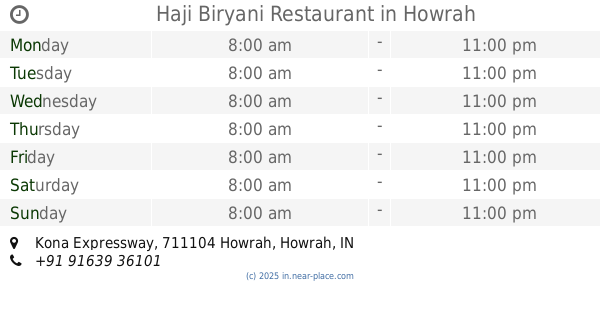
Haji Biryani Restaurant
Kona Expressway, Chatterjihat, Shibpur, Howrah
Restaurant
read more
1.097 km
Moghal Empire Restaurant
Kona Expressway, Chatterjihat, Shibpur, Howrah
Restaurant
read more
1.363 km
Mio Amore
Sarat Chatterjee Road, Chatterjihat, Shibpur, Howrah
Restaurant
read more
1.363 km
Corner Pub
Sarat Chatterjee Road, Chatterjihat, Shibpur, Howrah
Restaurant
read more
1.542 km
RAJLAKKHI
694, Sarat Chatterjee Road, Belepole, Shibpur, Howrah
Restaurant
read more
1.643 km
Bhuri Bhoj Restaurant
1/9, Andul Road, Naora, Shibpur, Howrah
Restaurant
read more
1.901 km
FIESTA BAR & RESTAURANT
Doctor Bholanath Chakraborty Sarani, Belepole, Baruipara, Shibpur, Howrah
Restaurant
read more
2.068 km
Kochida Resturent
Baksara Road, Baksara, Howrah
Restaurant
read more
📑
all categories
Accounting
Administrative area level 1
Administrative area level 2
Airport
Amusement park
Aquarium
Art gallery
Atm
Bakery
Bank
Bar
Beauty salon
Bicycle store
Book store
Bowling alley
Bus station
Cafe
Campground
Car dealer
Car rental
Car repair
Car wash
Casino
Cemetery
Church
City hall
Clothing store
Colloquial area
Convenience store
Courthouse
Dentist
Department store
Doctor
Electrician
Electronics store
Embassy
Finance
Fire station
Florist
Food
Funeral home
Furniture store
Gas station
General contractor
Grocery or supermarket
Gym
Hair care
Hardware store
Health
Hindu Temple
Home goods store
Hospital
Insurance agency
Intersection
Jewelry store
Laundry
Lawyer
Library
Light rail station
Liquor store
Local government office
Locality
Locksmith
Lodging
Meal delivery
Meal takeaway
Mosque
Movie rental
Movie theater
Moving company
Museum
Natural feature
Neighborhood
Night club
Painter
Park
Parking
Pet store
Pharmacy
Physiotherapist
Place of worship
Plumber
Point of interest
Police
Political
Post office
Premise
Real estate agency
Restaurant
Roofing contractor
Route
Rv park, camping
School
Shoe store
Shopping mall
Spa
Stadium
Storage
Store
Subpremise
Subway station
Supermarket
Synagogue
Taxi stand
Train station
Transit station
Travel agency
University
Veterinary care
Zoo
administrative area level 3
sublocality level 1
sublocality level 2
sublocality level 3
↑