Restaurant nearby Kurla
Coronavirus disease (COVID-19) Situation
confirmed cases
45035393
deaths
533570
India
Restaurant nearby Kurla
Kurla
192, Central Salsette Tramway Road, Friends Colony, Hallow Pul, Kurla, Mumbai India
contacts phone
:
+91
Latitude:
19.0758073
, Longitude:
72.8783975
read more
nearest Restaurant
80 m
the junction
Mumbai
Restaurant
read more
80 m
sadguru restaurant
Friends Colony, Kismat Nagar, Kurla, Mumbai
Restaurant
read more
80 m
Ganesh Palace Restaurant & Bar
Shanti Nagar, Mahakali Caves Road, Friends Colony, Kismat Nagar, Kurla, Andheri(E)
Restaurant
read more
80 m
Shyam
Friends Colony, Hallow Pul, Kurla, Mumbai
Restaurant
read more
147 m
Hotel Dashmesh Punjab
Lal Bahadur Shastri Road, Kurla West, Kurla, Kurla West
Restaurant
read more
183 m
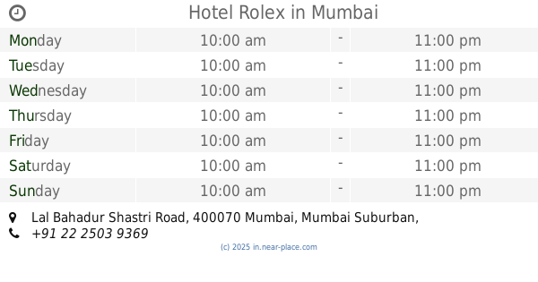
Hotel Rolex
Lal Bahadur Shastri Road, Friends Colony, Hallow Pul, Kurla, Mumbai
Restaurant
read more
186 m
Sheikh's MARHABA Restaurant
OPP kalpana cinema LBS Road Kurla west, Mumbai
Restaurant
read more
193 m
Kokan Swad
Shop.No.2, Dwarkapuri Bldg, L B S Marg, Kurla West, Mumbai
Restaurant
read more
498 m
Lakhnow Zaika
1, Lal Bahadur Shastri Road, Ambedkar Nagar, Kurla West, Kurla, Mumbai
Restaurant
read more
563 m
Vrindavan Bar & Resturent
Gazal Gol Building Opp Bhabhia Hospital, Kurla West, Mumbai
Restaurant
read more
626 m
Taste budz
Shop number. 3 ambika darshan, Match Factory Lane, Shri krishna chawk, Kurla West, Mumbai
Restaurant
read more
708 m
Amber
67,, Monisha, S V Road, Kurla West, Kurla, Andheri(W)
Restaurant
read more
895 m
Archana Bhadouria
Kurla West, Kurla, architects
Restaurant
read more
954 m
ARABIAN LUQMA
Shop No. 173/5, Near Sheetal Cinema, L.B.S. West, LBS Marg, Kurla, Mumbai
Restaurant
read more
1.132 km
HITCHKI
Plot No. C- 54 & 55, Unit No.002, G-Block, FIFC Building,, Bandra-Kurla Complex, BKC Road, Bandra (East), Mumbai
Restaurant
read more
📑
all categories
Accounting
Administrative area level 1
Administrative area level 2
Airport
Amusement park
Aquarium
Art gallery
Atm
Bakery
Bank
Bar
Beauty salon
Bicycle store
Book store
Bowling alley
Bus station
Cafe
Campground
Car dealer
Car rental
Car repair
Car wash
Casino
Cemetery
Church
City hall
Clothing store
Colloquial area
Convenience store
Courthouse
Dentist
Department store
Doctor
Electrician
Electronics store
Embassy
Finance
Fire station
Florist
Food
Funeral home
Furniture store
Gas station
General contractor
Grocery or supermarket
Gym
Hair care
Hardware store
Health
Hindu Temple
Home goods store
Hospital
Insurance agency
Intersection
Jewelry store
Laundry
Lawyer
Library
Light rail station
Liquor store
Local government office
Locality
Locksmith
Lodging
Meal delivery
Meal takeaway
Mosque
Movie rental
Movie theater
Moving company
Museum
Natural feature
Neighborhood
Night club
Painter
Park
Parking
Pet store
Pharmacy
Physiotherapist
Place of worship
Plumber
Point of interest
Police
Political
Post office
Premise
Real estate agency
Restaurant
Roofing contractor
Route
Rv park, camping
School
Shoe store
Shopping mall
Spa
Stadium
Storage
Store
Subpremise
Subway station
Supermarket
Synagogue
Taxi stand
Train station
Transit station
Travel agency
University
Veterinary care
Zoo
administrative area level 3
sublocality level 1
sublocality level 2
sublocality level 3
↑