Restaurant nearby Meal N Sour Refreshment
India
Restaurant nearby Meal N Sour Refreshment
Meal N Sour Refreshment
Neer Nagar, Indore India
contacts phone
:
+91
Latitude:
22.709451
, Longitude:
75.9209199
read more
nearest Restaurant
740 m
Echidna Restrobrew
Bicholi Mardana Road, Bicholi Mardana
Restaurant
read more
750 m
Echidna Restobrew
16/1, Opposite Grand Exotica, Sampat Farms, Bicholi Mardana, Indore
Restaurant
read more
769 m
GFC Restaurant
Godhra Hwy, Near Agrawal Public School, Bicholi Mardana, Indore
Restaurant
read more
772 m
GFC Restaurant
The GFC Restaurant, Bicholi Mardana Road, Near Agrawal Public School, Bicholi Mardana, Indore
Restaurant
read more
1.005 km
साऊथ इंडियन फ़ूड
scheme.no.140 near state bank of
Restaurant
read more
1.071 km
SAINI USSAL POHA
84, Godhra Highway, Greater Brajeshwari, Indore
Restaurant
read more
1.1 km
sneha sendwich
shop no 6 nsc tower pipliyana indore, Indore
Restaurant
read more
1.109 km
RCM 3 INDORE
10, Godhra Highway, Greater Brijeshwari Annexe, Sahara City Homes, Indore
Restaurant
read more
1.194 km
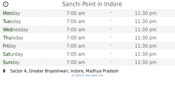
Sanchi Point
Sector A, Greater Brajeshwari, Indore
Restaurant
read more
1.356 km
Edhichna resto bar
Bicholi Mardana, Indore
Restaurant
read more
1.441 km
Jayram Hotel
127, Eastern Ring Rd Brajeshwari Extension, Piliyahana, Eastern Ring Road, Piliyahana, Brajeshwari Extension, Chauhan Nagar, Indore
Restaurant
read more
1.517 km
Top N Town Ice Crea Jahnvi Creation
Shop No. 1, 112, Brijeshwari Ext, Lothar College Road, Indore
Restaurant
read more
1.53 km
Prashant Restaurant
Brajeshwari Extension, Sahara City Homes, Indore
Restaurant
read more
1.617 km
Mini Street Cafe
fb 36 schme94, Service Road, Indore
Restaurant
read more
2.271 km
Narbada Sweet's
18, Mayur Nagar, Musakhedi, Indore
Restaurant
read more
📑
all categories
Accounting
Administrative area level 1
Administrative area level 2
Airport
Amusement park
Aquarium
Art gallery
Atm
Bakery
Bank
Bar
Beauty salon
Bicycle store
Book store
Bowling alley
Bus station
Cafe
Campground
Car dealer
Car rental
Car repair
Car wash
Casino
Cemetery
Church
City hall
Clothing store
Colloquial area
Convenience store
Courthouse
Dentist
Department store
Doctor
Electrician
Electronics store
Embassy
Finance
Fire station
Florist
Food
Funeral home
Furniture store
Gas station
General contractor
Grocery or supermarket
Gym
Hair care
Hardware store
Health
Hindu Temple
Home goods store
Hospital
Insurance agency
Intersection
Jewelry store
Laundry
Lawyer
Library
Light rail station
Liquor store
Local government office
Locality
Locksmith
Lodging
Meal delivery
Meal takeaway
Mosque
Movie rental
Movie theater
Moving company
Museum
Natural feature
Neighborhood
Night club
Painter
Park
Parking
Pet store
Pharmacy
Physiotherapist
Place of worship
Plumber
Point of interest
Police
Political
Post office
Premise
Real estate agency
Restaurant
Roofing contractor
Route
Rv park, camping
School
Shoe store
Shopping mall
Spa
Stadium
Storage
Store
Subpremise
Subway station
Supermarket
Synagogue
Taxi stand
Train station
Transit station
Travel agency
University
Veterinary care
Zoo
administrative area level 3
sublocality level 1
sublocality level 2
sublocality level 3
↑