Restaurant nearby Vrunadavan Cateres
India
Restaurant nearby Vrunadavan Cateres
Vrunadavan Cateres
SR 159/B/5, Kharalwadi, Pimpri Colony, Pimpri-Chinchwad India
contacts phone
:
+91
Latitude:
18.625283
, Longitude:
73.809573
read more
nearest Restaurant
193 m
Laziz Biryani And Caterers
157/A, Kharalwadi Road, Atma Nagar, Kharalwadi, Pimpri Colony, Pimpri-Chinchwad
Restaurant
read more
306 m
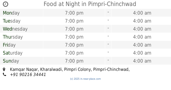
Food at Night
Kamgar Nagar, Kharalwadi, Pimpri Colony, Pimpri-Chinchwad
Restaurant
read more
344 m
Hotel Chhaya
Ta 3-7-004, Ajmera Complex, Pimpri, Pimpri, Pune
Restaurant
read more
430 m
Denim Bistro - Pimpri
Plot No.2, Near Ambedkar Chowk, Pimpri Bhosari Road, Pimpri, Pune
Restaurant
read more
456 m
Hotel Ratna Veg
2, Shatlejatat Dhandge Path, MIDC, Pimpri Colony, Pimpri-Chinchwad
Restaurant
read more
480 m
Sankalp Fast Food
Sukhwani Avenue, Opposite Dr. Beck's, Pimpri - Bhosari Road, Pimpri Colony, Pimpri-Chinchwad
Restaurant
read more
528 m
Aaram Kolhapur Durbar
Pimpri Colony, Pimpri-Chinchwad
Restaurant
read more
682 m
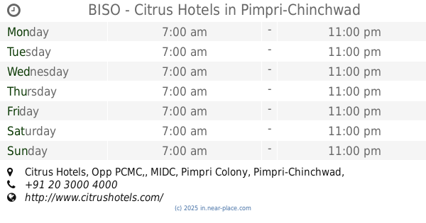
BISO - Citrus Hotels
Citrus Hotels, Opp PCMC,, Pimpri Colony
Restaurant
read more
804 m
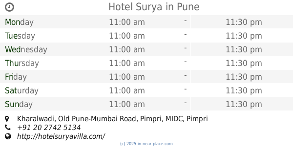
Hotel Surya
Kharalwadi, Old Pune-Mumbai Road, Pimpri, Pune
Restaurant
read more
1.015 km
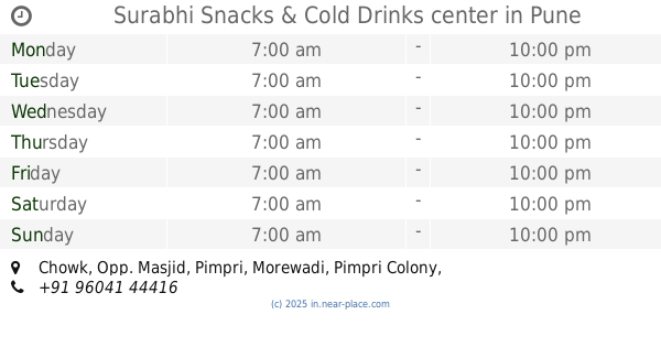
Surabhi Snacks & Cold Drinks center
Chowk, Opp. Masjid, Pimpri, Morewadi, Pimpri Colony, Pune
Restaurant
read more
1.042 km
Jay Malhar Nastha House
Mide Road, J Morwadi,, Morewadi, Pimpri Colony, Pimpri-Chinchwad
Restaurant
read more
1.09 km
Modern Fine Dine Restaurant
Sr No. 5831/5832 Opp. City International School Pimpri, Morewadi, Pimpri Colony, Pune
Restaurant
read more
1.176 km
Hotel Arihant
PWD 1/8, Gaylord Chowk, JN Road, Shastri Nagar, Pimpri Colony, Pimpri-Chinchwad
Restaurant
read more
1.186 km
Hotel Karachi Bhavan
Plot No 2/5, Opp Sai Sagar Steel, J.N Road, Pimpri, Pune
Restaurant
read more
1.302 km
Wai Wai City Pimpri
3rd Floor, City One Mall, Old Mumbai - Pune Highway, Morewadi, Pimpri Colony, Pune
Restaurant
read more
📑
all categories
Accounting
Administrative area level 1
Administrative area level 2
Airport
Amusement park
Aquarium
Art gallery
Atm
Bakery
Bank
Bar
Beauty salon
Bicycle store
Book store
Bowling alley
Bus station
Cafe
Campground
Car dealer
Car rental
Car repair
Car wash
Casino
Cemetery
Church
City hall
Clothing store
Colloquial area
Convenience store
Courthouse
Dentist
Department store
Doctor
Electrician
Electronics store
Embassy
Finance
Fire station
Florist
Food
Funeral home
Furniture store
Gas station
General contractor
Grocery or supermarket
Gym
Hair care
Hardware store
Health
Hindu Temple
Home goods store
Hospital
Insurance agency
Intersection
Jewelry store
Laundry
Lawyer
Library
Light rail station
Liquor store
Local government office
Locality
Locksmith
Lodging
Meal delivery
Meal takeaway
Mosque
Movie rental
Movie theater
Moving company
Museum
Natural feature
Neighborhood
Night club
Painter
Park
Parking
Pet store
Pharmacy
Physiotherapist
Place of worship
Plumber
Point of interest
Police
Political
Post office
Premise
Real estate agency
Restaurant
Roofing contractor
Route
Rv park, camping
School
Shoe store
Shopping mall
Spa
Stadium
Storage
Store
Subpremise
Subway station
Supermarket
Synagogue
Taxi stand
Train station
Transit station
Travel agency
University
Veterinary care
Zoo
administrative area level 3
sublocality level 1
sublocality level 2
sublocality level 3
↑