School nearby BISHOP'S PRE- PRIMARY SCHOOL .AMRAVATI
India
School nearby BISHOP'S PRE- PRIMARY SCHOOL .AMRAVATI
BISHOP'S PRE- PRIMARY SCHOOL .AMRAVATI
Wadali Road, SRPF Colony, Amravati India
contacts phone
:
+91
Latitude:
20.9279777
, Longitude:
77.7929167
read more
nearest School
300 m
Shriram Primary English School
SRPF Colony, Amravati
School
read more
378 m
Govt. Amravati Munciple School
Laghuvetan Colony, Amravati
School
read more
386 m
M.N.Pa Ucch Prathamik Marathi Shala
Wadali Bus Stop, Amravati
School
read more
445 m
Minatai Thakre Prathmik Marathi Shala, Wadali, Amravati
Laghuvetan Colony, Amravati
School
read more
788 m
Dr. Narendra Bhivapurakar Andha Vidyalay
Chaprasi Pura, Kanwar Nagar, Om Shivniketan Colony, Shivneri Colony, Amravati
School
read more
807 m
Blinds School
Chaprasi Pura, Shivneri Colony, Amravati
School
read more
1.089 km
Girl Hostel
Chaprasi Pura, Kanwar Nagar, Om Shivniketan Colony, Shivneri Colony, Amravati
School
read more
1.126 km
Sainik mulinche vasatigruh
Jail Road, Chaprasi Pura, Shivneri Colony, Amravati
School
read more
1.216 km
Sakal mulinche vasatigruh
Chaprasi Pura, Kanwar Nagar, Om Shivniketan Colony, Shivneri Colony, Amravati
School
read more
1.317 km
UDCT Amaravati
SRPF Colony
School
read more
1.349 km
Imran Decoration
indira ghandhi nagar, Shivneri Colony, Amravati
School
read more
1.505 km
MNP Primary Marathi School No. 21
Wadarpura, Amravati
School
read more
1.67 km
Amravati Egg Center
biyani square, Amravati
School
read more
1.73 km
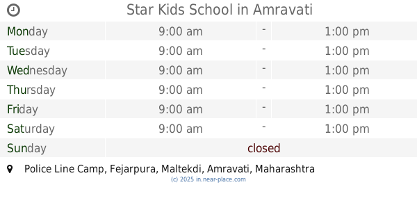
Star Kids School
Police Line Camp, Fejarpura, Maltekdi, Amravati
School
read more
1.74 km
vasudha tai deshmukh agree collage amaravti
Maharashtra State Highway 243, Vir Tanaji Nagar, Shivneri Colony, Amravati
School
read more
📑
all categories
Accounting
Administrative area level 1
Administrative area level 2
Airport
Amusement park
Aquarium
Art gallery
Atm
Bakery
Bank
Bar
Beauty salon
Bicycle store
Book store
Bowling alley
Bus station
Cafe
Campground
Car dealer
Car rental
Car repair
Car wash
Casino
Cemetery
Church
City hall
Clothing store
Colloquial area
Convenience store
Courthouse
Dentist
Department store
Doctor
Electrician
Electronics store
Embassy
Finance
Fire station
Florist
Food
Funeral home
Furniture store
Gas station
General contractor
Grocery or supermarket
Gym
Hair care
Hardware store
Health
Hindu Temple
Home goods store
Hospital
Insurance agency
Intersection
Jewelry store
Laundry
Lawyer
Library
Light rail station
Liquor store
Local government office
Locality
Locksmith
Lodging
Meal delivery
Meal takeaway
Mosque
Movie rental
Movie theater
Moving company
Museum
Natural feature
Neighborhood
Night club
Painter
Park
Parking
Pet store
Pharmacy
Physiotherapist
Place of worship
Plumber
Point of interest
Police
Political
Post office
Premise
Real estate agency
Restaurant
Roofing contractor
Route
Rv park, camping
School
Shoe store
Shopping mall
Spa
Stadium
Storage
Store
Subpremise
Subway station
Supermarket
Synagogue
Taxi stand
Train station
Transit station
Travel agency
University
Veterinary care
Zoo
administrative area level 3
sublocality level 1
sublocality level 2
sublocality level 3
↑