School nearby Joshi Car Driving School
India
School nearby Joshi Car Driving School
Joshi Car Driving School
Raisen Road, Bijli Colony, Govindpura, Bhopal India
contacts phone
:
+91
Latitude:
23.25314
, Longitude:
77.4395474
read more
nearest School
218 m
Govt.Primary School Old Subhash Nagar
Old Subhash Nagar, Govind Garden, Bhopal
School
read more
705 m
Govt. School, Bijlee Nagar
M P E B Colony, Govindpura, Bhopal
School
read more
747 m
Shaman Sanskriti Vidya Niketan
Raisen Rd, Iqbal Colony, Ashoka Garden, Bhopal
School
read more
908 m
Sandhya Jain Study Circle
A-250, Ashoka Garden Road, New Ashoka Garden, Bhopal
School
read more
921 m
Wisdom Public Higher Secondary School
Ashoka Garden , Infront Of Uchit Mulya KI Dukan, New Ashoka Garden, Ashoka Garden, Bhopal
School
read more
993 m
Saraswati Vidya Mandir
New Ashoka Garden, Near Overhead Water Tank, Ashoka Garden, Bhopal
School
read more
1.006 km
Nehru Higher Secondary
Raisen Rd, Ashoka Garden, Bhopal
School
read more
1.017 km
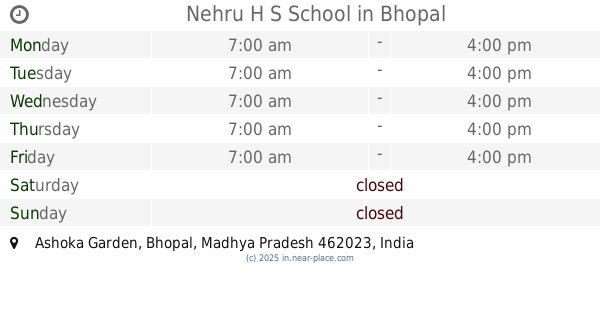
Nehru H S School
Ashoka Garden, Bhopal
School
read more
1.091 km
Capital Petrol Pumb Kali Mandir
A-14, Ashoka Garden, Bhopal
School
read more
1.091 km
Kidspark Preschools
303, Ashok Vihar, Near Durga Dham Mandir, Ashoka Garden, Bhopal
School
read more
1.132 km
Pvt.HS.R.P.N.Model School
WARD NO 42,7-A,shanshah Garden, Bhopal Municipal Corporation
School
read more
1.196 km
Laxmi Mandi School
80 Feet Road, Ashok Vihar, Bhopal
School
read more
1.209 km
Government Laxmi Mandi Higher Secondary School
4, 80 Feet Road, Near Laxmi Mandi School, Ashoka Garden, Ashok Vihar, Bhopal
School
read more
1.264 km
New Sunshine Convent School
38-A, Friends Colony, Near Nagar Manhet, Ashoka Garden, Samrat Colony, Bhopal
School
read more
1.304 km
G.B. Pant Higher Secondary School
55-B, Shed Colony, Shaid Colony, Ashoka Garden, Bhopal
School
read more
📑
all categories
Accounting
Administrative area level 1
Administrative area level 2
Airport
Amusement park
Aquarium
Art gallery
Atm
Bakery
Bank
Bar
Beauty salon
Bicycle store
Book store
Bowling alley
Bus station
Cafe
Campground
Car dealer
Car rental
Car repair
Car wash
Casino
Cemetery
Church
City hall
Clothing store
Colloquial area
Convenience store
Courthouse
Dentist
Department store
Doctor
Electrician
Electronics store
Embassy
Finance
Fire station
Florist
Food
Funeral home
Furniture store
Gas station
General contractor
Grocery or supermarket
Gym
Hair care
Hardware store
Health
Hindu Temple
Home goods store
Hospital
Insurance agency
Intersection
Jewelry store
Laundry
Lawyer
Library
Light rail station
Liquor store
Local government office
Locality
Locksmith
Lodging
Meal delivery
Meal takeaway
Mosque
Movie rental
Movie theater
Moving company
Museum
Natural feature
Neighborhood
Night club
Painter
Park
Parking
Pet store
Pharmacy
Physiotherapist
Place of worship
Plumber
Point of interest
Police
Political
Post office
Premise
Real estate agency
Restaurant
Roofing contractor
Route
Rv park, camping
School
Shoe store
Shopping mall
Spa
Stadium
Storage
Store
Subpremise
Subway station
Supermarket
Synagogue
Taxi stand
Train station
Transit station
Travel agency
University
Veterinary care
Zoo
administrative area level 3
sublocality level 1
sublocality level 2
sublocality level 3
↑