Store nearby Mangala Traders Indore
India
Store nearby Mangala Traders Indore
Mangala Traders Indore
G-4, Gagendra House, 7/1, Maharani Road, Opposite Big Railway Line, Siyaganj, Indore India
contacts phone
:
+91
Latitude:
22.7168327
, Longitude:
75.8674075
read more
nearest Store
200 m
Nix Sales Corporation
M-10, Babadeep Complex, Maharani Road, Siyaganj, Siyaganj, Indore
Store
read more
263 m
Sharma Namkeen Bhandar
Jawahar Marg, Chhoti Gwaltoli, Indore
Store
read more
323 m
M.SAIFUDDIN N.ASGERALI
Siyaganj Main Road, Siyaganj, Indore
Store
read more
549 m
American Tourister
88/6, Phadnis complex, MG Road, Khatipura, Indore
Store
read more
555 m
Yash Opticals
9,10, Mahatma Gandhi Road, Opposite Topkhana Gurudwara, Khatipura, Indore
Store
read more
599 m
Captain Fancy Bag
Shop No. 2, 128, Main Road, Jagjivan Ram Mohalla, Ranipura, Indore
Store
read more
634 m
Shibaam signage factory
10/3 Rauji Bazaar Juni Indore, Opp Bada Rawla Gate, Indore
Store
read more
703 m
Agrawal and Dhoot Chartered Account
164, RNT Marg, Nehru Park 2, Chhoti Gwaltoli, Indore
Store
read more
748 m
Raj Rajeshwari Engineering Works
Shop No 16, Nasia Road, Opposite Gujarati College, Nasia Road, Indore
Store
read more
791 m
Herbal Shoppe
No. 6, Sanjay Setu hopping Complex, Sanjay Setu Road, Adjoining Jawahar Marg, Sanjay Setu, Rajwada, Siyaganj, Indore
Store
read more
843 m
Verma Ayurvedic Stores
No.G-35, 164, Mulay Tower, Mahatma Gandhi Road, Tope Khana, Near Mrignayani Emporium, Indore
Store
read more
1.038 km
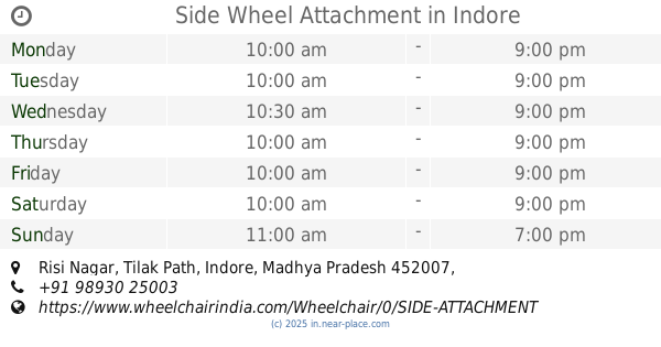
Side Wheel Attachment
Risi Nagar, Tilak Path, Indore
Store
read more
1.096 km
Jain Sev Bhandar
23, Netaji Subhash Marg, Chiman Bagh, Indore
Store
read more
1.1 km
A.R. Graphics
11/2, Ala Pura Main Road, Near Mahesh Book Depot, Juni Indore, Ala Pura, Indore
Store
read more
1.382 km
Agarwal Stationery
71, Ushaganj, Near Chavni Square, Indore
Store
read more
📑
all categories
Accounting
Administrative area level 1
Administrative area level 2
Airport
Amusement park
Aquarium
Art gallery
Atm
Bakery
Bank
Bar
Beauty salon
Bicycle store
Book store
Bowling alley
Bus station
Cafe
Campground
Car dealer
Car rental
Car repair
Car wash
Casino
Cemetery
Church
City hall
Clothing store
Colloquial area
Convenience store
Courthouse
Dentist
Department store
Doctor
Electrician
Electronics store
Embassy
Finance
Fire station
Florist
Food
Funeral home
Furniture store
Gas station
General contractor
Grocery or supermarket
Gym
Hair care
Hardware store
Health
Hindu Temple
Home goods store
Hospital
Insurance agency
Intersection
Jewelry store
Laundry
Lawyer
Library
Light rail station
Liquor store
Local government office
Locality
Locksmith
Lodging
Meal delivery
Meal takeaway
Mosque
Movie rental
Movie theater
Moving company
Museum
Natural feature
Neighborhood
Night club
Painter
Park
Parking
Pet store
Pharmacy
Physiotherapist
Place of worship
Plumber
Point of interest
Police
Political
Post office
Premise
Real estate agency
Restaurant
Roofing contractor
Route
Rv park, camping
School
Shoe store
Shopping mall
Spa
Stadium
Storage
Store
Subpremise
Subway station
Supermarket
Synagogue
Taxi stand
Train station
Transit station
Travel agency
University
Veterinary care
Zoo
administrative area level 3
sublocality level 1
sublocality level 2
sublocality level 3
↑