Store nearby MC Trading
India
Store nearby MC Trading
MC Trading
Pan Bazaar, Guwahati India
contacts phone
:
+91
Latitude:
26.1846449
, Longitude:
91.746846
read more
nearest Store
358 m
Button Badges Shop
Lakshmnath Bezbaruah Road, Dighalipukhuri, Guwahati
Store
read more
430 m
Guwahati Optical Mart
MN Road, Pan Bazaar, Guwahati
Store
read more
468 m
India Tea Store
PWD Colony, Paltan Bazaar, Guwahati
Store
read more
501 m
Shree Kamal Electricals
Shop No.16,Basement, T.N.Tower, Mahapurush Damodardev Path, Paltan Bazaar, Guwahati
Store
read more
517 m
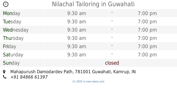
Nilachal Tailoring
Mahapurush Damodardev Path, Near Rong Mahal Hotel, Pan Bazaar, Guwahati
Store
read more
590 m
IOSIS
41, Md Tayabulla Rd, Tayabulla Campus, Md Tayabulla Road, Tayabulla Campus, Digholi Pukhuri East, Dighalipukhuri, Guwahati
Store
read more
676 m
Berlia Pipes, Wires & Fans (Super Distributor for North Eastern Region)
GS Road, Paltan Bazaar, Guwahati
Store
read more
749 m
Mahendra Dutta India & Company
Hem Baruah Road, Lakhtokia, Fancy Bazaar, Guwahati
Store
read more
763 m
Susamay Watch House Optical
MD Shah Road, Nepali Mandir, Nilam Market, Paltan Bazaar, Guwahati
Store
read more
791 m
Kay Bee Printers
5th Floor, Hem Baruah Road, Shoppers Point, Fancy Bazaar, Guwahati
Store
read more
890 m
Labanya Press
64, Fatic Chandra Road,, Uzanbazar, Guwahati
Store
read more
932 m
BASKIN ROBBINS
Sai Enterprise,Latasil, Opposite to Planeterium,Uzanbazar, Guwahati
Store
read more
1.001 km
Dhanvantree Agencies
Dr B. Baruah Road, Manglunia Bhawan, Opp Nehru Stadium, Ulubari, Sarania Hills, Guwahati
Store
read more
1.038 km
Pharmacy
81, Doctor B Borooah Road, Ulubari, Guwahati
Store
read more
1.184 km
Ankita Sports
Dr. B.Baruah Road, Opposite B. Baruah College, Ulubari, Guwahati
Store
read more
📑
all categories
Accounting
Administrative area level 1
Administrative area level 2
Airport
Amusement park
Aquarium
Art gallery
Atm
Bakery
Bank
Bar
Beauty salon
Bicycle store
Book store
Bowling alley
Bus station
Cafe
Campground
Car dealer
Car rental
Car repair
Car wash
Casino
Cemetery
Church
City hall
Clothing store
Colloquial area
Convenience store
Courthouse
Dentist
Department store
Doctor
Electrician
Electronics store
Embassy
Finance
Fire station
Florist
Food
Funeral home
Furniture store
Gas station
General contractor
Grocery or supermarket
Gym
Hair care
Hardware store
Health
Hindu Temple
Home goods store
Hospital
Insurance agency
Intersection
Jewelry store
Laundry
Lawyer
Library
Light rail station
Liquor store
Local government office
Locality
Locksmith
Lodging
Meal delivery
Meal takeaway
Mosque
Movie rental
Movie theater
Moving company
Museum
Natural feature
Neighborhood
Night club
Painter
Park
Parking
Pet store
Pharmacy
Physiotherapist
Place of worship
Plumber
Point of interest
Police
Political
Post office
Premise
Real estate agency
Restaurant
Roofing contractor
Route
Rv park, camping
School
Shoe store
Shopping mall
Spa
Stadium
Storage
Store
Subpremise
Subway station
Supermarket
Synagogue
Taxi stand
Train station
Transit station
Travel agency
University
Veterinary care
Zoo
administrative area level 3
sublocality level 1
sublocality level 2
sublocality level 3
↑